Bicaz elevation
Bicaz (Maramureş, Comuna Bicaz), Romania elevation is 279 meters and Bicaz elevation in feet is 915 ft above sea level [src 1]. Bicaz is a seat of a second-order administrative division (feature code) with elevation that is 27 meters (89 ft) bigger than average city elevation in Romania.
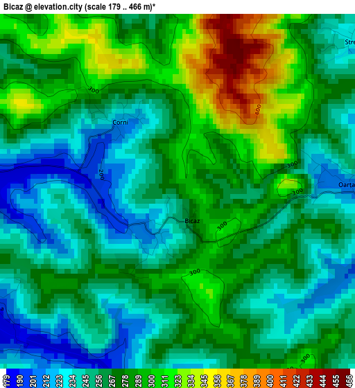
Below is the Elevation map of Bicaz, which displays elevation range with different colors. Scale of the first map is from 179 to 466 m (587 to 1529 ft) with average elevation of 270.4 meters (=887 ft) [note 1]
These maps also provides idea of topography and contour of this city, they are displayed at different zoom levels. More info about maps, scale and edge coordinates you can find below images.
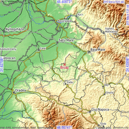
| \ | Map #1 | Topo.Map |
| Scale [m] | 179..466 m | × |
| Scale [ft] | 587..1529 ft | × |
| Average | 270.4 m = 887 ft | × |
| Width | 6.61 km = 4.1 mi | 211.4 km = 131.4 mi |
| Height | 6.61 km = 4.1 mi | 211.4 km = 131.4 mi |
| ↑Max Latitude | 47.496369° | 48.40873° |
| Latitude at center | 47.46667° | 47.46667° |
| ↓Min Latitude | 47.436954° | 46.50741° |
| ← Min Longitude | 22.989385° | 21.62708° |
| Longitude center | 23.03333° | 23.03333° |
| →Max Longitude | 23.077275° | 24.43958° |
Nearby cities:
Cities around Bicaz sort by population:
• Bogdand elevation 178 m
9.4 km,  233°
233°
• Hodod 243 m
7.4 km,  180°
180°
• Sălăţig 182 m
13.4 km,  145°
145°
• Chieşd 187 m
14.6 km, 230°
• Socond 164 m
12.8 km,  330°
330°
• Băiţa de sub Codru 256 m
11.5 km,  49°
49°
• Şamşud 229 m
14.4 km,  205°
205°
• Băseşti 226 m
9 km,  78°
78°
• Oarţa de Jos 202 m
7.1 km,  97°
97°
• Stâna 221 m
6.9 km,  311°
311°
• Babța 243 m
6.9 km,  261°
261°
• Cehu Silvaniei 218 m
12.3 km,  119°
119°
Multilingual:
 En español:
Bicaz elevación 279 m.
 En France:
Bicaz élévation 279 m.


Sources and notes:
- [note 1] Map square and city borders are not equal. Map elevation data is calculated only from area inside that square.
- [src 1] Elevation data from geonames database provided with same terms of usage.
- [src 2] The elevation map of Bicaz is generated using elevation data from NASA's 3 arcsec (90m) resolution SRTM data.
- [src 3] Base (background) map © OpenStreetMap contributors tiles are generated by Geofabrik and OpenTopoMap.
Copyright & License:
This Bicaz Elevation Map is licensed under CC BY-SA. You may reuse any part from this page, if you give a proper credit by linking to this URL:
 More info on terms of use page.