Bicaz-Chei elevation
Bicaz-Chei (Neamţ, Comuna Bicaz Chei), Romania elevation is 834 meters and Bicaz-Chei elevation in feet is 2736 ft above sea level [src 1]. Bicaz-Chei is a seat of a second-order administrative division (feature code) with elevation that is 582 meters (1909 ft) bigger than average city elevation in Romania.
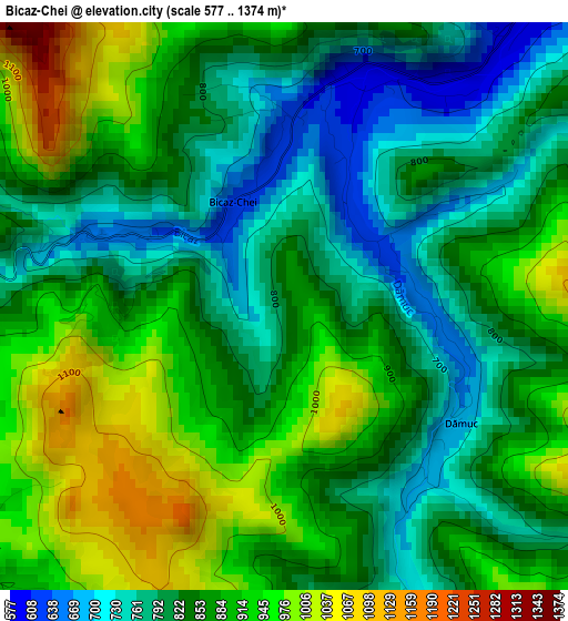
Below is the Elevation map of Bicaz-Chei, which displays elevation range with different colors. Scale of the first map is from 577 to 1374 m (1893 to 4508 ft) with average elevation of 859 meters (=2818 ft) [note 1]
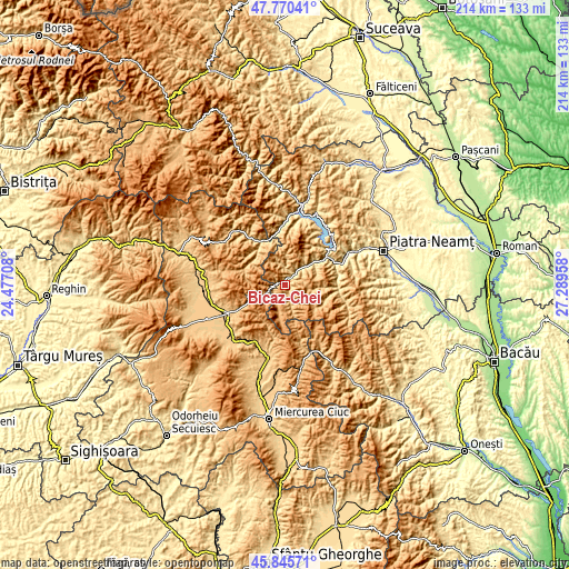
These maps also provides idea of topography and contour of this city, they are displayed at different zoom levels. More info about maps, scale and edge coordinates you can find below images.
| \ | Map #1 | Topo.Map |
| Scale [m] | 577..1374 m | × |
| Scale [ft] | 1893..4508 ft | × |
| Average | 859 m = 2818 ft | × |
| Width | 6.69 km = 4.2 mi | 214 km = 133 mi |
| Height | 6.69 km = 4.2 mi | 214 km = 133 mi |
| ↑Max Latitude | 46.846735° | 47.77041° |
| Latitude at center | 46.81667° | 46.81667° |
| ↓Min Latitude | 46.786588° | 45.84571° |
| ← Min Longitude | 25.839385° | 24.47708° |
| Longitude center | 25.88333° | 25.88333° |
| →Max Longitude | 25.927275° | 27.28958° |
Nearby cities:
Cities around Bicaz-Chei sort by population:
• Gheorgheni elevation 816 m
23.9 km,  244°
244°
• Bicaz 744 m
17.8 km,  51°
51°
• Bălan 890 m
19.3 km,  197°
197°
• Bicazu Ardelean 630 m
5.3 km, 45°
• Tulgheş 920 m
17.3 km,  329°
329°
• Tarcău 466 m
19.8 km,  73°
73°
• Dămuc 777 m
2.2 km,  145°
145°
• Taşca 555 m
13.7 km, 47°
• Valea Rece 864 m
22.5 km,  165°
165°
• Telec 681 m
7 km,  356°
356°
• Dodeni 425 m
20 km, 52°
• Corbu 693 m
23.2 km,  323°
323°
Multilingual:
 En español:
Bicaz-Chei elevación 834 m.
 En France:
Bicaz-Chei élévation 834 m.
 Auf Deutsch:
Bicaz-Chei höhe über dem Meeresspiegel ist 834 m.

Sources and notes:
- [note 1] Map square and city borders are not equal. Map elevation data is calculated only from area inside that square.
- [src 1] Elevation data from geonames database provided with same terms of usage.
- [src 2] The elevation map of Bicaz-Chei is generated using elevation data from NASA's 3 arcsec (90m) resolution SRTM data.
- [src 3] Base (background) map © OpenStreetMap contributors tiles are generated by Geofabrik and OpenTopoMap.
Copyright & License:
This Bicaz-Chei Elevation Map is licensed under CC BY-SA. You may reuse any part from this page, if you give a proper credit by linking to this URL:
 More info on terms of use page.