Bârlogu elevation
Bârlogu (Arges, Comuna Negraşi), Romania elevation is 217 meters and Bârlogu elevation in feet is 712 ft above sea level [src 1]. Bârlogu is a populated place (feature code) with elevation that is 35 meters (115 ft) smaller than average city elevation in Romania.
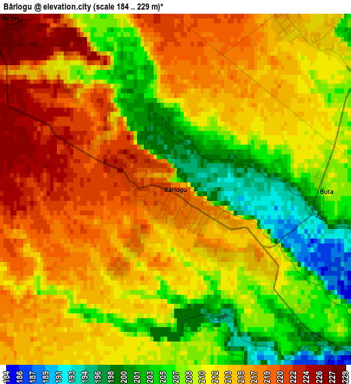
Below is the Elevation map of Bârlogu, which displays elevation range with different colors. Scale of the first map is from 184 to 229 m (604 to 751 ft) with average elevation of 211.5 meters (=694 ft) [note 1]
These maps also provides idea of topography and contour of this city, they are displayed at different zoom levels. More info about maps, scale and edge coordinates you can find below images.
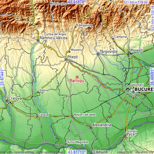
| \ | Map #1 | Topo.Map |
| Scale [m] | 184..229 m | × |
| Scale [ft] | 604..751 ft | × |
| Average | 211.5 m = 694 ft | × |
| Width | 6.96 km = 4.3 mi | 222.6 km = 138.3 mi |
| Height | 6.96 km = 4.3 mi | 222.6 km = 138.3 mi |
| ↑Max Latitude | 44.657847° | 45.61878° |
| Latitude at center | 44.62658° | 44.62658° |
| ↓Min Latitude | 44.595296° | 43.61713° |
| ← Min Longitude | 25.036715° | 23.67441° |
| Longitude center | 25.08066° | 25.08066° |
| →Max Longitude | 25.124605° | 26.48691° |
Nearby cities:
Cities around Bârlogu sort by population:
• Buzoeşti elevation 219 m
13.8 km,  249°
249°
• Răteşti 226 m
12.6 km,  19°
19°
• Recea 167 m
11.5 km,  206°
206°
• Morteni 196 m
12.9 km,  69°
69°
• Rociu 214 m
5.8 km,  319°
319°
• Negraşi 201 m
4.1 km,  136°
136°
• Mozăceni 169 m
9.5 km,  134°
134°
• Teiu 218 m
4.7 km, 18°
• Șerbănești 242 m
9.3 km,  311°
311°
• Cornățel 211 m
11.2 km,  242°
242°
• Humele 195 m
13.9 km,  216°
216°
• Pătuleni 214 m
13.5 km,  29°
29°
Multilingual:
 En español:
Bârlogu elevación 217 m.
 En France:
Bârlogu élévation 217 m.


Sources and notes:
- [note 1] Map square and city borders are not equal. Map elevation data is calculated only from area inside that square.
- [src 1] Elevation data from geonames database provided with same terms of usage.
- [src 2] The elevation map of Bârlogu is generated using elevation data from NASA's 3 arcsec (90m) resolution SRTM data.
- [src 3] Base (background) map © OpenStreetMap contributors tiles are generated by Geofabrik and OpenTopoMap.
Copyright & License:
This Bârlogu Elevation Map is licensed under CC BY-SA. You may reuse any part from this page, if you give a proper credit by linking to this URL:
 More info on terms of use page.