Bârzava elevation
Bârzava (Arad, Comuna Bârzava), Romania elevation is 209 meters and Bârzava elevation in feet is 686 ft above sea level [src 1]. Bârzava is a seat of a second-order administrative division (feature code) with elevation that is 43 meters (141 ft) smaller than average city elevation in Romania.
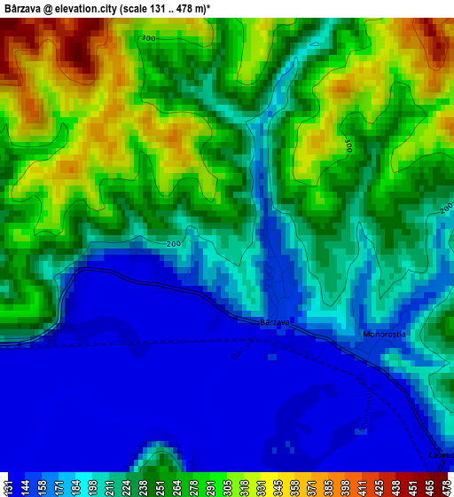
Below is the Elevation map of Bârzava, which displays elevation range with different colors. Scale of the first map is from 131 to 478 m (430 to 1568 ft) with average elevation of 225.5 meters (=740 ft) [note 1]
These maps also provides idea of topography and contour of this city, they are displayed at different zoom levels. More info about maps, scale and edge coordinates you can find below images.
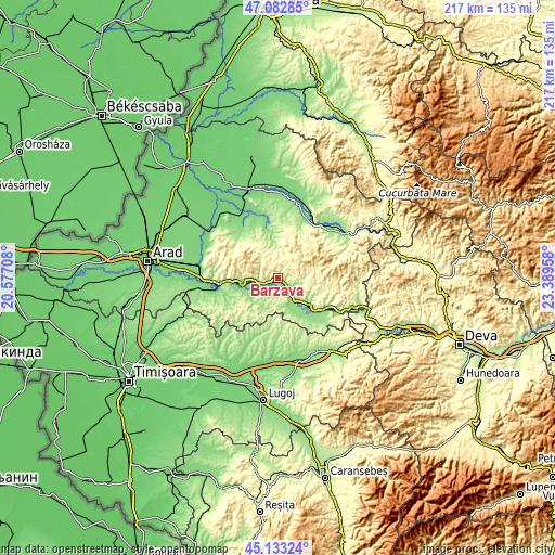
| \ | Map #1 | Topo.Map |
| Scale [m] | 131..478 m | × |
| Scale [ft] | 430..1568 ft | × |
| Average | 225.5 m = 740 ft | × |
| Width | 6.77 km = 4.2 mi | 216.8 km = 134.7 mi |
| Height | 6.77 km = 4.2 mi | 216.8 km = 134.7 mi |
| ↑Max Latitude | 46.147124° | 47.08285° |
| Latitude at center | 46.11667° | 46.11667° |
| ↓Min Latitude | 46.086199° | 45.13324° |
| ← Min Longitude | 21.939385° | 20.57708° |
| Longitude center | 21.98333° | 21.98333° |
| →Max Longitude | 22.027275° | 23.38958° |
Nearby cities:
Cities around Bârzava sort by population:
• Săvârşin elevation 169 m
22.3 km,  119°
119°
• Conop 135 m
8.2 km,  258°
258°
• Tauţ 140 m
19.2 km,  344°
344°
• Vărădia de Mureş 145 m
17 km,  130°
130°
• Birchiş 151 m
21.9 km,  139°
139°
• Chisindia 186 m
20.6 km,  25°
25°
• Dorgoş 152 m
13.7 km,  237°
237°
• Bata 148 m
11.8 km,  160°
160°
• Drauț 177 m
20.9 km,  320°
320°
• Nadăș 184 m
12.3 km,  348°
348°
• Ususău 132 m
14 km,  248°
248°
• Şiştarovăţ 206 m
22.3 km, 240°
Multilingual:
 En español:
Bârzava elevación 209 m.
 En France:
Bârzava élévation 209 m.


Sources and notes:
- [note 1] Map square and city borders are not equal. Map elevation data is calculated only from area inside that square.
- [src 1] Elevation data from geonames database provided with same terms of usage.
- [src 2] The elevation map of Bârzava is generated using elevation data from NASA's 3 arcsec (90m) resolution SRTM data.
- [src 3] Base (background) map © OpenStreetMap contributors tiles are generated by Geofabrik and OpenTopoMap.
Copyright & License:
This Bârzava Elevation Map is licensed under CC BY-SA. You may reuse any part from this page, if you give a proper credit by linking to this URL:
 More info on terms of use page.