Bogata elevation
Bogata (Mureş, Comuna Bogata), Romania elevation is 272 meters and Bogata elevation in feet is 892 ft above sea level [src 1]. Bogata is a seat of a second-order administrative division (feature code) with elevation that is 20 meters (66 ft) bigger than average city elevation in Romania.
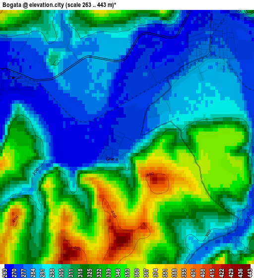
Below is the Elevation map of Bogata, which displays elevation range with different colors. Scale of the first map is from 263 to 443 m (863 to 1453 ft) with average elevation of 312.8 meters (=1026 ft) [note 1]
These maps also provides idea of topography and contour of this city, they are displayed at different zoom levels. More info about maps, scale and edge coordinates you can find below images.
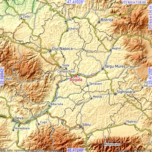
| \ | Map #1 | Topo.Map |
| Scale [m] | 263..443 m | × |
| Scale [ft] | 863..1453 ft | × |
| Average | 312.8 m = 1026 ft | × |
| Width | 6.73 km = 4.2 mi | 215.5 km = 133.9 mi |
| Height | 6.73 km = 4.2 mi | 215.4 km = 133.8 mi |
| ↑Max Latitude | 46.480269° | 47.41028° |
| Latitude at center | 46.45° | 46.45° |
| ↓Min Latitude | 46.419714° | 45.47249° |
| ← Min Longitude | 24.022725° | 22.66042° |
| Longitude center | 24.06667° | 24.06667° |
| →Max Longitude | 24.110615° | 25.47292° |
Nearby cities:
Cities around Bogata sort by population:
• Luduş elevation 272 m
4.5 km,  34°
34°
• Cheţani 273 m
3.2 km,  305°
305°
• Lunca Mureşului 275 m
12.9 km,  261°
261°
• Bârza 299 m
12.2 km,  24°
24°
• Luna 297 m
12.9 km,  299°
299°
• Cuci 274 m
6.6 km,  73°
73°
• Noşlac 303 m
11.6 km,  241°
241°
• Aţintiş 309 m
3.2 km,  125°
125°
• Gheja 272 m
0.3 km,  203°
203°
• Luncani 285 m
9.2 km,  285°
285°
• Sânger 301 m
13.2 km, 24°
• Bichiş 388 m
9.6 km,  164°
164°
Multilingual:
 En español:
Bogata elevación 272 m.
 En France:
Bogata élévation 272 m.


Sources and notes:
- [note 1] Map square and city borders are not equal. Map elevation data is calculated only from area inside that square.
- [src 1] Elevation data from geonames database provided with same terms of usage.
- [src 2] The elevation map of Bogata is generated using elevation data from NASA's 3 arcsec (90m) resolution SRTM data.
- [src 3] Base (background) map © OpenStreetMap contributors tiles are generated by Geofabrik and OpenTopoMap.
Copyright & License:
This Bogata Elevation Map is licensed under CC BY-SA. You may reuse any part from this page, if you give a proper credit by linking to this URL:
 More info on terms of use page.