Bogdăneşti elevation
Bogdăneşti (Cluj, Comuna Mãguri-Rãcãtãu), Romania elevation is 1185 meters and Bogdăneşti elevation in feet is 3888 ft above sea level [src 1]. Bogdăneşti is a section of populated place (feature code) with elevation that is 933 meters (3061 ft) bigger than average city elevation in Romania.
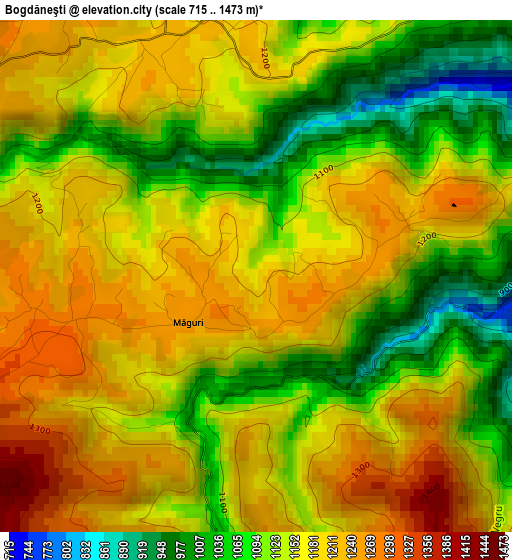
Below is the Elevation map of Bogdăneşti, which displays elevation range with different colors. Scale of the first map is from 715 to 1473 m (2346 to 4833 ft) with average elevation of 1156 meters (=3793 ft) [note 1]
These maps also provides idea of topography and contour of this city, they are displayed at different zoom levels. More info about maps, scale and edge coordinates you can find below images.
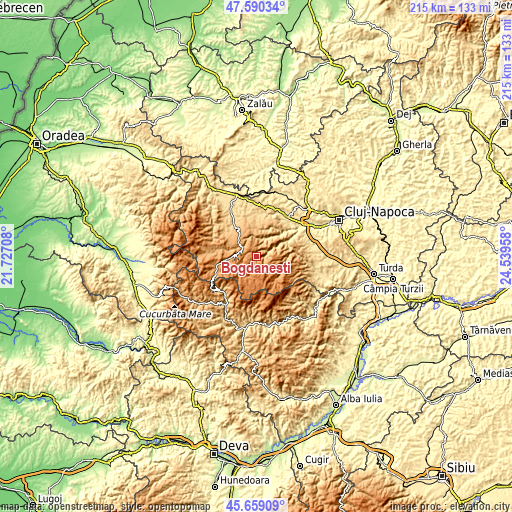
| \ | Map #1 | Topo.Map |
| Scale [m] | 715..1473 m | × |
| Scale [ft] | 2346..4833 ft | × |
| Average | 1156 m = 3793 ft | × |
| Width | 6.71 km = 4.2 mi | 214.7 km = 133.4 mi |
| Height | 6.71 km = 4.2 mi | 214.7 km = 133.4 mi |
| ↑Max Latitude | 46.663497° | 47.59034° |
| Latitude at center | 46.63333° | 46.63333° |
| ↓Min Latitude | 46.603146° | 45.65909° |
| ← Min Longitude | 23.089385° | 21.72708° |
| Longitude center | 23.13333° | 23.13333° |
| →Max Longitude | 23.177275° | 24.53958° |
Nearby cities:
Cities around Bogdăneşti sort by population:
• Gilău elevation 424 m
20.6 km,  57°
57°
• Căpuşu Mare 454 m
21 km,  37°
37°
• Călăţele 679 m
17.3 km,  329°
329°
• Mărgău 814 m
18.2 km,  315°
315°
• Mânăstireni 798 m
15.3 km,  345°
345°
• Mărişel 1058 m
1.9 km,  0°
0°
• Beliş 1103 m
7.9 km,  283°
283°
• Măguri 1278 m
2.4 km,  256°
256°
• Valea Ierii 864 m
16.6 km,  83°
83°
• Râșca 909 m
12 km, 350°
• Măguri-Răcătău 700 m
5 km, 75°
• Horea 746 m
20.2 km,  223°
223°
Multilingual:
 En español:
Bogdăneşti elevación 1185 m.
 En France:
Bogdăneşti élévation 1185 m.
 Auf Deutsch:
Bogdăneşti höhe über dem Meeresspiegel ist 1185 m.

Sources and notes:
- [note 1] Map square and city borders are not equal. Map elevation data is calculated only from area inside that square.
- [src 1] Elevation data from geonames database provided with same terms of usage.
- [src 2] The elevation map of Bogdăneşti is generated using elevation data from NASA's 3 arcsec (90m) resolution SRTM data.
- [src 3] Base (background) map © OpenStreetMap contributors tiles are generated by Geofabrik and OpenTopoMap.
Copyright & License:
This Bogdăneşti Elevation Map is licensed under CC BY-SA. You may reuse any part from this page, if you give a proper credit by linking to this URL:
 More info on terms of use page.