Bozovici elevation
Bozovici (Caraş-Severin, Comuna Bozovici), Romania elevation is 305 meters and Bozovici elevation in feet is 1001 ft above sea level [src 1]. Bozovici is a seat of a second-order administrative division (feature code) with elevation that is 53 meters (174 ft) bigger than average city elevation in Romania.
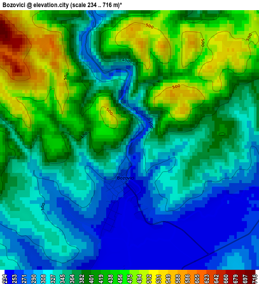
Below is the Elevation map of Bozovici, which displays elevation range with different colors. Scale of the first map is from 234 to 716 m (768 to 2349 ft) with average elevation of 372.3 meters (=1221 ft) [note 1]
These maps also provides idea of topography and contour of this city, they are displayed at different zoom levels. More info about maps, scale and edge coordinates you can find below images.
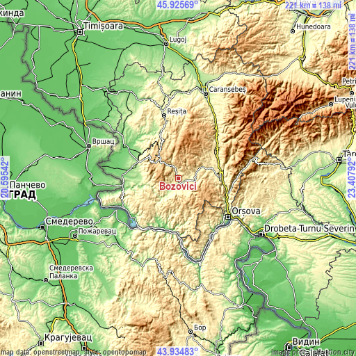
| \ | Map #1 | Topo.Map |
| Scale [m] | 234..716 m | × |
| Scale [ft] | 768..2349 ft | × |
| Average | 372.3 m = 1221 ft | × |
| Width | 6.92 km = 4.3 mi | 221.4 km = 137.6 mi |
| Height | 6.92 km = 4.3 mi | 221.4 km = 137.6 mi |
| ↑Max Latitude | 44.969989° | 45.92569° |
| Latitude at center | 44.93889° | 44.93889° |
| ↓Min Latitude | 44.907774° | 43.93483° |
| ← Min Longitude | 21.957725° | 20.59542° |
| Longitude center | 22.00167° | 22.00167° |
| →Max Longitude | 22.045615° | 23.40792° |
Nearby cities:
Cities around Bozovici sort by population:
• Anina elevation 755 m
19.3 km,  323°
323°
• Steierdorf 631 m
18.2 km, 319°
• Prigor 377 m
8.8 km,  90°
90°
• Bănia 286 m
5.9 km,  144°
144°
• Lăpuşnicu Mare 367 m
5.4 km,  237°
237°
• Eftimie Murgu 389 m
8.4 km,  120°
120°
• Gârnic 604 m
23.5 km,  223°
223°
• Şopotu Nou 418 m
15.4 km,  225°
225°
• Lăpuşnicel 388 m
18.4 km,  74°
74°
• Cărbunari 562 m
23.4 km, 240°
• Dalboșeț 249 m
9 km,  202°
202°
• Mehadica 359 m
23.3 km,  63°
63°
Multilingual:
 En español:
Bozovici elevación 305 m.
 En France:
Bozovici élévation 305 m.
 Auf Deutsch:
Bozovici höhe über dem Meeresspiegel ist 305 m.

Sources and notes:
- [note 1] Map square and city borders are not equal. Map elevation data is calculated only from area inside that square.
- [src 1] Elevation data from geonames database provided with same terms of usage.
- [src 2] The elevation map of Bozovici is generated using elevation data from NASA's 3 arcsec (90m) resolution SRTM data.
- [src 3] Base (background) map © OpenStreetMap contributors tiles are generated by Geofabrik and OpenTopoMap.
Copyright & License:
This Bozovici Elevation Map is licensed under CC BY-SA. You may reuse any part from this page, if you give a proper credit by linking to this URL:
 More info on terms of use page.