Bragadiru elevation
Bragadiru (Ilfov, Oraş Bragadiru), Romania elevation is 82 meters and Bragadiru elevation in feet is 269 ft above sea level [src 1]. Bragadiru is a seat of a second-order administrative division (feature code) with elevation that is 170 meters (558 ft) smaller than average city elevation in Romania.
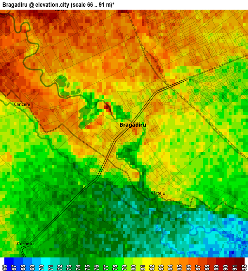
Below is the Elevation map of Bragadiru, which displays elevation range with different colors. Scale of the first map is from 66 to 91 m (217 to 299 ft) with average elevation of 79.7 meters (=261 ft) [note 1]
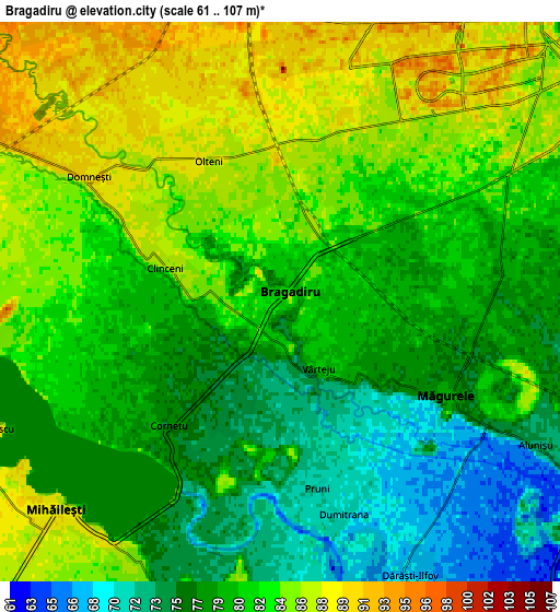
These maps also provides idea of topography and contour of this city, they are displayed at different zoom levels. More info about maps, scale and edge coordinates you can find below images.
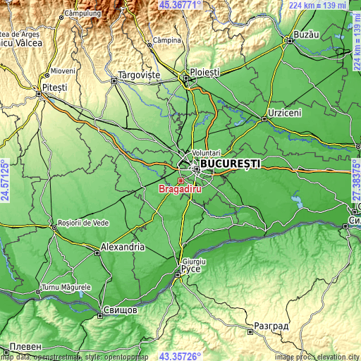
| \ | Map #1 | Map #2 | Topo.Map |
| Scale [m] | 66..91 m | 61..107 m | × |
| Scale [ft] | 217..299 ft | 200..351 ft | × |
| Average | 79.7 m = 261 ft | 80.8 m = 265 ft | × |
| Width | 6.99 km = 4.3 mi | 13.97 km = 8.7 mi | 223.5 km = 138.9 mi |
| Height | 6.99 km = 4.3 mi | 13.97 km = 8.7 mi | 223.5 km = 138.9 mi |
| ↑Max Latitude | 44.402515° | 44.433903° | 45.36771° |
| Latitude at center | 44.37111° | 44.37111° | 44.37111° |
| ↓Min Latitude | 44.339688° | 44.30825° | 43.35726° |
| ← Min Longitude | 25.933555° | 25.889609° | 24.57125° |
| Longitude center | 25.9775° | 25.9775° | 25.9775° |
| →Max Longitude | 26.021445° | 26.065391° | 27.38375° |
Nearby cities:
Cities around Bragadiru sort by population:
• Sector 5 elevation 81 m
7.7 km,  75°
75°
• Măgurele 76 m
5 km,  117°
117°
• Mihăileşti 87 m
7.4 km,  228°
228°
• Domneşti-Sârbi 82 m
5 km,  285°
285°
• Domnești 91 m
5.8 km,  302°
302°
• Cornetu 78 m
4.4 km,  221°
221°
• Clinceni 84 m
1.8 km,  277°
277°
• Dărăşti-Ilfov 68 m
7.6 km,  154°
154°
• Vârteju 80 m
2 km, 145°
• Popești 82 m
7.5 km,  188°
188°
• Alunișu 73 m
7.4 km, 119°
• Olteni 84 m
3.3 km,  318°
318°
Multilingual:
 En español:
Bragadiru elevación 82 m.
 En France:
Bragadiru élévation 82 m.
 Auf Deutsch:
Bragadiru höhe über dem Meeresspiegel ist 82 m.

Sources and notes:
- [note 1] Map square and city borders are not equal. Map elevation data is calculated only from area inside that square.
- [src 1] Elevation data from geonames database provided with same terms of usage.
- [src 2] The elevation map of Bragadiru is generated using elevation data from NASA's 3 arcsec (90m) resolution SRTM data.
- [src 3] Base (background) map © OpenStreetMap contributors tiles are generated by Geofabrik and OpenTopoMap.
Copyright & License:
This Bragadiru Elevation Map is licensed under CC BY-SA. You may reuse any part from this page, if you give a proper credit by linking to this URL:
 More info on terms of use page.