Buda elevation
Buda (Iaşi, Comuna Lespezi), Romania elevation is 287 meters and Buda elevation in feet is 942 ft above sea level [src 1]. Buda is a populated place (feature code) with elevation that is 35 meters (115 ft) bigger than average city elevation in Romania.
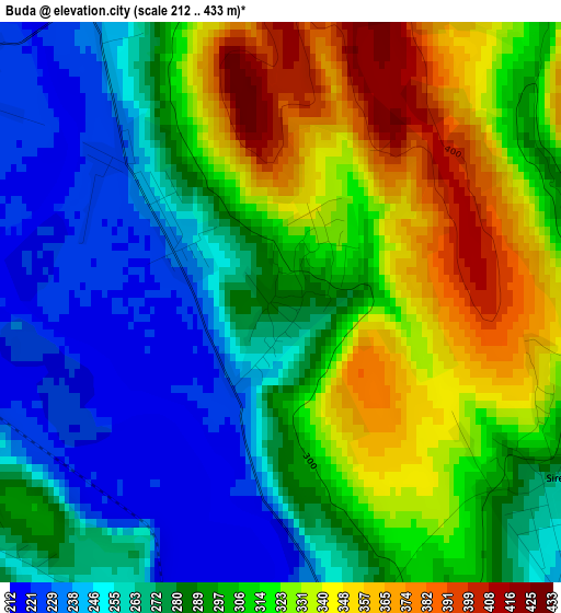
Below is the Elevation map of Buda, which displays elevation range with different colors. Scale of the first map is from 212 to 433 m (696 to 1421 ft) with average elevation of 295.2 meters (=969 ft) [note 1]
These maps also provides idea of topography and contour of this city, they are displayed at different zoom levels. More info about maps, scale and edge coordinates you can find below images.
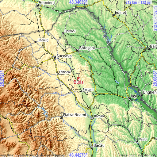
| \ | Map #1 | Topo.Map |
| Scale [m] | 212..433 m | × |
| Scale [ft] | 696..1421 ft | × |
| Average | 295.2 m = 969 ft | × |
| Width | 6.61 km = 4.1 mi | 211.7 km = 131.5 mi |
| Height | 6.61 km = 4.1 mi | 211.6 km = 131.5 mi |
| ↑Max Latitude | 47.432915° | 48.34639° |
| Latitude at center | 47.40318° | 47.40318° |
| ↓Min Latitude | 47.373428° | 46.44278° |
| ← Min Longitude | 26.634405° | 25.2721° |
| Longitude center | 26.67835° | 26.67835° |
| →Max Longitude | 26.722295° | 28.0846° |
Nearby cities:
Cities around Buda sort by population:
• Dolhasca elevation 231 m
6.8 km,  299°
299°
• Lespezi 296 m
4.4 km,  158°
158°
• Tătăruşi 338 m
8.4 km,  224°
224°
• Sireţel 260 m
4.2 km,  94°
94°
• Heci 228 m
6.8 km,  190°
190°
• Probota 289 m
5.1 km,  233°
233°
• Gulia 243 m
5.3 km,  280°
280°
• Budeni 252 m
1.9 km,  309°
309°
• Hârtoape 242 m
9.7 km, 158°
• Dolheștii Mici 259 m
10.2 km,  291°
291°
• Pietrosu 303 m
8.7 km, 217°
• Vânători 327 m
8.1 km,  126°
126°
Multilingual:
 En español:
Buda elevación 287 m.
 En France:
Buda élévation 287 m.


Sources and notes:
- [note 1] Map square and city borders are not equal. Map elevation data is calculated only from area inside that square.
- [src 1] Elevation data from geonames database provided with same terms of usage.
- [src 2] The elevation map of Buda is generated using elevation data from NASA's 3 arcsec (90m) resolution SRTM data.
- [src 3] Base (background) map © OpenStreetMap contributors tiles are generated by Geofabrik and OpenTopoMap.
Copyright & License:
This Buda Elevation Map is licensed under CC BY-SA. You may reuse any part from this page, if you give a proper credit by linking to this URL:
 More info on terms of use page.