Cămăraşu elevation
Cămăraşu (Cluj, Comuna Cămăraşu), Romania elevation is 334 meters and Cămăraşu elevation in feet is 1096 ft above sea level [src 1]. Cămăraşu is a seat of a second-order administrative division (feature code) with elevation that is 82 meters (269 ft) bigger than average city elevation in Romania.
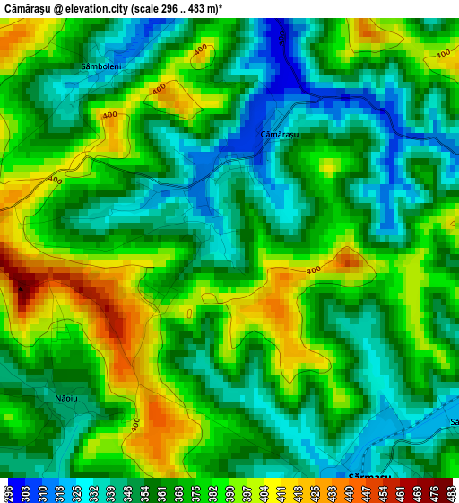
Below is the Elevation map of Cămăraşu, which displays elevation range with different colors. Scale of the first map is from 296 to 483 m (971 to 1585 ft) with average elevation of 367.1 meters (=1204 ft) [note 1]
These maps also provides idea of topography and contour of this city, they are displayed at different zoom levels. More info about maps, scale and edge coordinates you can find below images.
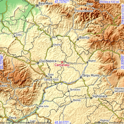
| \ | Map #1 | Topo.Map |
| Scale [m] | 296..483 m | × |
| Scale [ft] | 971..1585 ft | × |
| Average | 367.1 m = 1204 ft | × |
| Width | 6.69 km = 4.2 mi | 214.1 km = 133 mi |
| Height | 6.69 km = 4.2 mi | 214.1 km = 133 mi |
| ↑Max Latitude | 46.813414° | 47.73767° |
| Latitude at center | 46.78333° | 46.78333° |
| ↓Min Latitude | 46.75323° | 45.81177° |
| ← Min Longitude | 24.089385° | 22.72708° |
| Longitude center | 24.13333° | 24.13333° |
| →Max Longitude | 24.177275° | 25.53958° |
Nearby cities:
Cities around Cămăraşu sort by population:
• Sărmaşu elevation 340 m
4.5 km,  145°
145°
• Frata 403 m
11.2 km,  214°
214°
• Mociu 350 m
7.8 km,  283°
283°
• Cătina 337 m
8.3 km,  27°
27°
• Suatu 386 m
12.8 km,  261°
261°
• Geaca 398 m
9.6 km,  344°
344°
• Buza 452 m
13 km,  5°
5°
• Pălatca 397 m
13.6 km,  303°
303°
• Balda 332 m
5.6 km,  171°
171°
• Sânpetru de Câmpie 343 m
12.4 km,  127°
127°
• Silivașu de Câmpie 376 m
12.7 km,  90°
90°
• Miheşu de Câmpie 363 m
11.2 km, 173°
Multilingual:
 En español:
Cămăraşu elevación 334 m.
 En France:
Cămăraşu élévation 334 m.
 Auf Deutsch:
Cămăraşu höhe über dem Meeresspiegel ist 334 m.

Sources and notes:
- [note 1] Map square and city borders are not equal. Map elevation data is calculated only from area inside that square.
- [src 1] Elevation data from geonames database provided with same terms of usage.
- [src 2] The elevation map of Cămăraşu is generated using elevation data from NASA's 3 arcsec (90m) resolution SRTM data.
- [src 3] Base (background) map © OpenStreetMap contributors tiles are generated by Geofabrik and OpenTopoMap.
Copyright & License:
This Cămăraşu Elevation Map is licensed under CC BY-SA. You may reuse any part from this page, if you give a proper credit by linking to this URL:
 More info on terms of use page.