Căpleni elevation
Căpleni (Satu Mare, Comuna Căpleni), Romania elevation is 116 meters and Căpleni elevation in feet is 381 ft above sea level [src 1]. Căpleni is a seat of a second-order administrative division (feature code) with elevation that is 136 meters (446 ft) smaller than average city elevation in Romania.
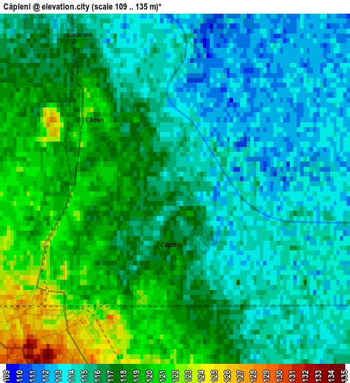
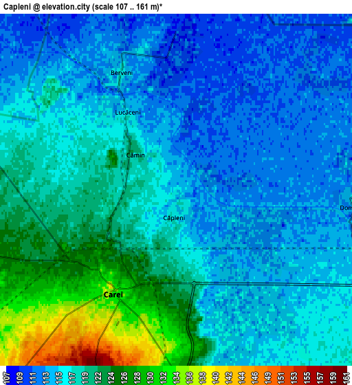
Below is the Elevation map of Căpleni, which displays elevation range with different colors. Scale of the first map is from 109 to 135 m (358 to 443 ft) with average elevation of 116.1 meters (=381 ft) [note 1]
These maps also provides idea of topography and contour of this city, they are displayed at different zoom levels. More info about maps, scale and edge coordinates you can find below images.
| \ | Map #1 | Map #2 | Topo.Map |
| Scale [m] | 109..135 m | 107..161 m | × |
| Scale [ft] | 358..443 ft | 351..528 ft | × |
| Average | 116.1 m = 381 ft | 118 m = 387 ft | × |
| Width | 6.57 km = 4.1 mi | 13.15 km = 8.2 mi | 210.4 km = 130.7 mi |
| Height | 6.57 km = 4.1 mi | 13.15 km = 8.2 mi | 210.4 km = 130.7 mi |
| ↑Max Latitude | 47.746228° | 47.775769° | 48.65421° |
| Latitude at center | 47.71667° | 47.71667° | 47.71667° |
| ↓Min Latitude | 47.687095° | 47.657504° | 46.76195° |
| ← Min Longitude | 22.456055° | 22.412109° | 21.09375° |
| Longitude center | 22.5° | 22.5° | 22.5° |
| →Max Longitude | 22.543945° | 22.587891° | 23.90625° |
Nearby cities:
Cities around Căpleni sort by population:
• Carei elevation 139 m
4.5 km,  213°
213°
• Sanislău 133 m
15.5 km,  233°
233°
• Moftinu Mare 118 m
13.7 km,  114°
114°
• Berveni 113 m
4.5 km,  326°
326°
• Tiream 124 m
11.4 km,  192°
192°
• Foieni 125 m
8.9 km,  258°
258°
• Urziceni 119 m
7.7 km,  283°
283°
• Cămin 118 m
2 km,  310°
310°
• Ciumești 133 m
13.3 km,  243°
243°
• Moftinu Mic 122 m
8.2 km, 113°
• Lucăceni 116 m
3.2 km, 329°
• Domănești 113 m
6.7 km,  95°
95°
Multilingual:
 En español:
Căpleni elevación 116 m.
 En France:
Căpleni élévation 116 m.


Sources and notes:
- [note 1] Map square and city borders are not equal. Map elevation data is calculated only from area inside that square.
- [src 1] Elevation data from geonames database provided with same terms of usage.
- [src 2] The elevation map of Căpleni is generated using elevation data from NASA's 3 arcsec (90m) resolution SRTM data.
- [src 3] Base (background) map © OpenStreetMap contributors tiles are generated by Geofabrik and OpenTopoMap.
Copyright & License:
This Căpleni Elevation Map is licensed under CC BY-SA. You may reuse any part from this page, if you give a proper credit by linking to this URL:
 More info on terms of use page.