Căpreni elevation
Căpreni (Gorj, Comuna Căpreni), Romania elevation is 244 meters and Căpreni elevation in feet is 801 ft above sea level [src 1]. Căpreni is a seat of a second-order administrative division (feature code) with elevation that is 8 meters (26 ft) smaller than average city elevation in Romania.
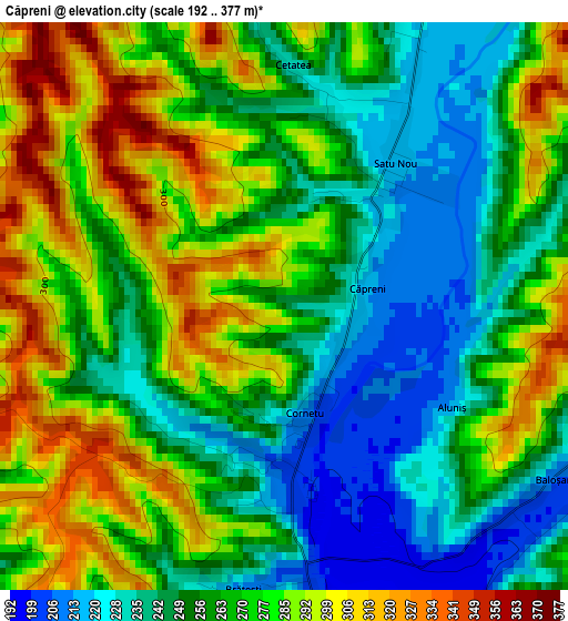
Below is the Elevation map of Căpreni, which displays elevation range with different colors. Scale of the first map is from 192 to 377 m (630 to 1237 ft) with average elevation of 266.4 meters (=874 ft) [note 1]
These maps also provides idea of topography and contour of this city, they are displayed at different zoom levels. More info about maps, scale and edge coordinates you can find below images.
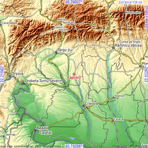
| \ | Map #1 | Topo.Map |
| Scale [m] | 192..377 m | × |
| Scale [ft] | 630..1237 ft | × |
| Average | 266.4 m = 874 ft | × |
| Width | 6.94 km = 4.3 mi | 222.1 km = 138 mi |
| Height | 6.94 km = 4.3 mi | 222.1 km = 138 mi |
| ↑Max Latitude | 44.781201° | 45.74007° |
| Latitude at center | 44.75° | 44.75° |
| ↓Min Latitude | 44.718782° | 43.74268° |
| ← Min Longitude | 23.572725° | 22.21042° |
| Longitude center | 23.61667° | 23.61667° |
| →Max Longitude | 23.660615° | 25.02292° |
Nearby cities:
Cities around Căpreni sort by population:
• Turburea elevation 150 m
8.7 km,  244°
244°
• Aninoasa 155 m
10.5 km,  270°
270°
• Stejari 240 m
5.6 km,  70°
70°
• Stoina 188 m
7.5 km,  169°
169°
• Dănciuleşti 257 m
10.7 km,  99°
99°
• Săuleşti 224 m
11.9 km,  297°
297°
• Hurezani 227 m
6.2 km,  25°
25°
• Poiana 146 m
12.8 km,  211°
211°
• Costești 190 m
13.7 km,  261°
261°
• Andreești 168 m
6.8 km,  310°
310°
• Crușeț 166 m
13.6 km,  163°
163°
• Tălpaș 223 m
12.7 km,  126°
126°
Multilingual:
 En español:
Căpreni elevación 244 m.
 En France:
Căpreni élévation 244 m.


Sources and notes:
- [note 1] Map square and city borders are not equal. Map elevation data is calculated only from area inside that square.
- [src 1] Elevation data from geonames database provided with same terms of usage.
- [src 2] The elevation map of Căpreni is generated using elevation data from NASA's 3 arcsec (90m) resolution SRTM data.
- [src 3] Base (background) map © OpenStreetMap contributors tiles are generated by Geofabrik and OpenTopoMap.
Copyright & License:
This Căpreni Elevation Map is licensed under CC BY-SA. You may reuse any part from this page, if you give a proper credit by linking to this URL:
 More info on terms of use page.