Cerna elevation
Cerna (Tulcea, Comuna Cerna), Romania elevation is 85 meters and Cerna elevation in feet is 279 ft above sea level [src 1]. Cerna is a seat of a second-order administrative division (feature code) with elevation that is 167 meters (548 ft) smaller than average city elevation in Romania.
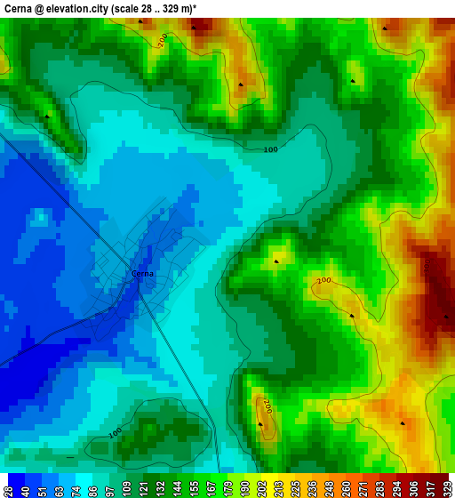
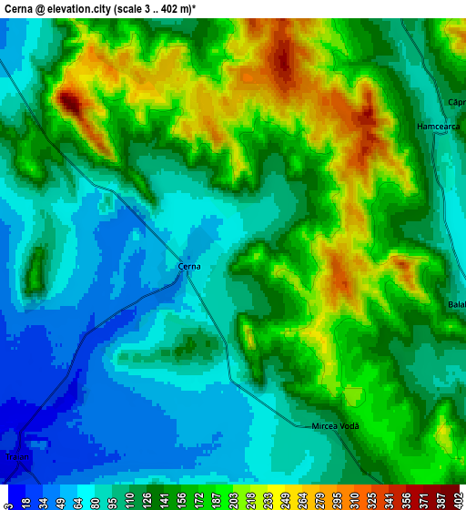
Below is the Elevation map of Cerna, which displays elevation range with different colors. Scale of the first map is from 28 to 329 m (92 to 1079 ft) with average elevation of 128.3 meters (=421 ft) [note 1]
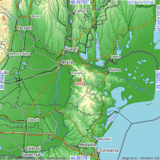
These maps also provides idea of topography and contour of this city, they are displayed at different zoom levels. More info about maps, scale and edge coordinates you can find below images.
| \ | Map #1 | Map #2 | Topo.Map |
| Scale [m] | 28..329 m | 3..402 m | × |
| Scale [ft] | 92..1079 ft | 10..1319 ft | × |
| Average | 128.3 m = 421 ft | 134.5 m = 441 ft | × |
| Width | 6.9 km = 4.3 mi | 13.8 km = 8.6 mi | 220.8 km = 137.2 mi |
| Height | 6.9 km = 4.3 mi | 13.8 km = 8.6 mi | 220.8 km = 137.2 mi |
| ↑Max Latitude | 45.11435° | 45.145354° | 46.06762° |
| Latitude at center | 45.08333° | 45.08333° | 45.08333° |
| ↓Min Latitude | 45.052293° | 45.021239° | 44.08178° |
| ← Min Longitude | 28.272725° | 28.228779° | 26.91042° |
| Longitude center | 28.31667° | 28.31667° | 28.31667° |
| →Max Longitude | 28.360615° | 28.404561° | 29.72292° |
Nearby cities:
Cities around Cerna sort by population:
• Greci elevation 25 m
12.9 km,  329°
329°
• Niculiţel 86 m
17.2 km,  49°
49°
• Izvoarele 54 m
17.9 km,  108°
108°
• Turcoaia 2 m
11.1 km,  289°
289°
• Carcaliu 13 m
17.2 km,  310°
310°
• Ciucurova 206 m
21.2 km,  141°
141°
• Peceneaga 13 m
16.2 km,  242°
242°
• Dorobanţu 224 m
15.3 km,  194°
194°
• Valea Teilor 168 m
13.8 km,  76°
76°
• Hamcearca 344 m
5.4 km, 46°
• Horia 118 m
12.8 km,  125°
125°
• Traian 9 m
8.8 km,  226°
226°
Multilingual:
 En español:
Cerna elevación 85 m.
 En France:
Cerna élévation 85 m.


Sources and notes:
- [note 1] Map square and city borders are not equal. Map elevation data is calculated only from area inside that square.
- [src 1] Elevation data from geonames database provided with same terms of usage.
- [src 2] The elevation map of Cerna is generated using elevation data from NASA's 3 arcsec (90m) resolution SRTM data.
- [src 3] Base (background) map © OpenStreetMap contributors tiles are generated by Geofabrik and OpenTopoMap.
Copyright & License:
This Cerna Elevation Map is licensed under CC BY-SA. You may reuse any part from this page, if you give a proper credit by linking to this URL:
 More info on terms of use page.