Cetate elevation
Cetate (Dolj, Comuna Cetate), Romania elevation is 41 meters and Cetate elevation in feet is 135 ft above sea level [src 1]. Cetate is a seat of a second-order administrative division (feature code) with elevation that is 211 meters (692 ft) smaller than average city elevation in Romania.
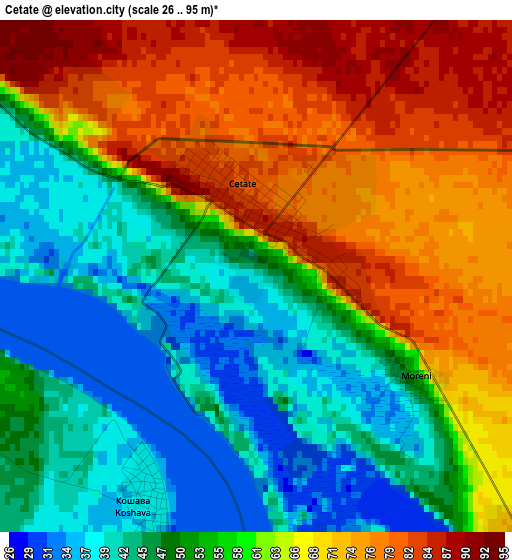
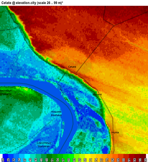
Below is the Elevation map of Cetate, which displays elevation range with different colors. Scale of the first map is from 26 to 95 m (85 to 312 ft) with average elevation of 58.5 meters (=192 ft) [note 1]
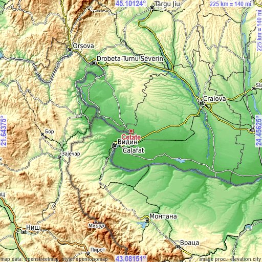
These maps also provides idea of topography and contour of this city, they are displayed at different zoom levels. More info about maps, scale and edge coordinates you can find below images.
| \ | Map #1 | Map #2 | Topo.Map |
| Scale [m] | 26..95 m | 26..99 m | × |
| Scale [ft] | 85..312 ft | 85..325 ft | × |
| Average | 58.5 m = 192 ft | 62.1 m = 204 ft | × |
| Width | 7.02 km = 4.4 mi | 14.04 km = 8.7 mi | 224.6 km = 139.6 mi |
| Height | 7.02 km = 4.4 mi | 14.04 km = 8.7 mi | 224.6 km = 139.6 mi |
| ↑Max Latitude | 44.13155° | 44.163083° | 45.10124° |
| Latitude at center | 44.1° | 44.1° | 44.1° |
| ↓Min Latitude | 44.068433° | 44.03685° | 43.08151° |
| ← Min Longitude | 23.006055° | 22.962109° | 21.64375° |
| Longitude center | 23.05° | 23.05° | 23.05° |
| →Max Longitude | 23.093945° | 23.137891° | 24.45625° |
Nearby cities:
Cities around Cetate sort by population:
• Calafat elevation 44 m
15.3 km,  217°
217°
• Moţăţei 69 m
12.1 km,  98°
98°
• Maglavit 73 m
8.4 km,  151°
151°
• Unirea 95 m
12 km,  62°
62°
• Salcia 43 m
10.8 km,  294°
294°
• Dârvari 109 m
11.1 km,  0°
0°
• Hunia 79 m
6.3 km,  141°
141°
• Gemeni 97 m
8.5 km,  17°
17°
• Basarabi 64 m
11 km,  197°
197°
• Izimșa 55 m
11.5 km,  319°
319°
• Dobridor 71 m
9.8 km,  77°
77°
• Obârșia de Câmp 93 m
9.8 km,  325°
325°
Multilingual:
 En español:
Cetate elevación 41 m.
 En France:
Cetate élévation 41 m.


Sources and notes:
- [note 1] Map square and city borders are not equal. Map elevation data is calculated only from area inside that square.
- [src 1] Elevation data from geonames database provided with same terms of usage.
- [src 2] The elevation map of Cetate is generated using elevation data from NASA's 3 arcsec (90m) resolution SRTM data.
- [src 3] Base (background) map © OpenStreetMap contributors tiles are generated by Geofabrik and OpenTopoMap.
Copyright & License:
This Cetate Elevation Map is licensed under CC BY-SA. You may reuse any part from this page, if you give a proper credit by linking to this URL:
 More info on terms of use page.