Chinteni elevation
Chinteni (Cluj, Comuna Chinteni), Romania elevation is 501 meters and Chinteni elevation in feet is 1644 ft above sea level [src 1]. Chinteni is a seat of a second-order administrative division (feature code) with elevation that is 249 meters (817 ft) bigger than average city elevation in Romania.
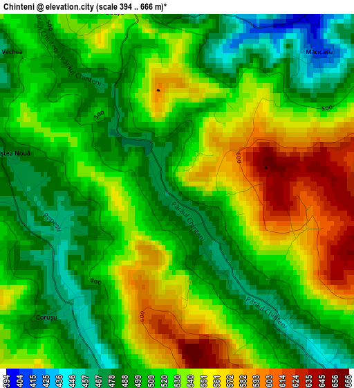
Below is the Elevation map of Chinteni, which displays elevation range with different colors. Scale of the first map is from 394 to 666 m (1293 to 2185 ft) with average elevation of 521.3 meters (=1710 ft) [note 1]
These maps also provides idea of topography and contour of this city, they are displayed at different zoom levels. More info about maps, scale and edge coordinates you can find below images.
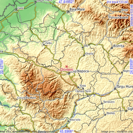
| \ | Map #1 | Topo.Map |
| Scale [m] | 394..666 m | × |
| Scale [ft] | 1293..2185 ft | × |
| Average | 521.3 m = 1710 ft | × |
| Width | 6.68 km = 4.2 mi | 213.8 km = 132.8 mi |
| Height | 6.68 km = 4.2 mi | 213.8 km = 132.8 mi |
| ↑Max Latitude | 46.896707° | 47.81952° |
| Latitude at center | 46.86667° | 46.86667° |
| ↓Min Latitude | 46.836616° | 45.8966° |
| ← Min Longitude | 23.489385° | 22.12708° |
| Longitude center | 23.53333° | 23.53333° |
| →Max Longitude | 23.577275° | 24.93958° |
Nearby cities:
Cities around Chinteni sort by population:
• Cluj-Napoca elevation 352 m
12.2 km,  155°
155°
• Baciu 395 m
7.5 km,  189°
189°
• Floreşti 366 m
13.8 km, 192°
• Sânpaul 409 m
9.1 km,  281°
281°
• Luna de Sus 393 m
15.6 km,  208°
208°
• Borşa 336 m
12.6 km,  53°
53°
• Aşchileu Dorna 436 m
13.5 km,  343°
343°
• Sânmărtin 399 m
4.5 km,  34°
34°
• Vultureni 423 m
11.4 km,  12°
12°
• Mera 408 m
8.3 km,  226°
226°
• Suceagu 418 m
10.5 km, 209°
• Gârbău 411 m
14.3 km,  254°
254°
Multilingual:
 En español:
Chinteni elevación 501 m.
 En France:
Chinteni élévation 501 m.
 Auf Deutsch:
Chinteni höhe über dem Meeresspiegel ist 501 m.

Sources and notes:
- [note 1] Map square and city borders are not equal. Map elevation data is calculated only from area inside that square.
- [src 1] Elevation data from geonames database provided with same terms of usage.
- [src 2] The elevation map of Chinteni is generated using elevation data from NASA's 3 arcsec (90m) resolution SRTM data.
- [src 3] Base (background) map © OpenStreetMap contributors tiles are generated by Geofabrik and OpenTopoMap.
Copyright & License:
This Chinteni Elevation Map is licensed under CC BY-SA. You may reuse any part from this page, if you give a proper credit by linking to this URL:
 More info on terms of use page.