Chirnogeni elevation
Chirnogeni (Constanța, Comuna Chirnogeni), Romania elevation is 118 meters and Chirnogeni elevation in feet is 387 ft above sea level [src 1]. Chirnogeni is a seat of a second-order administrative division (feature code) with elevation that is 134 meters (440 ft) smaller than average city elevation in Romania.
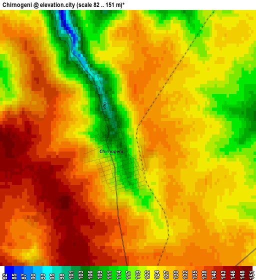
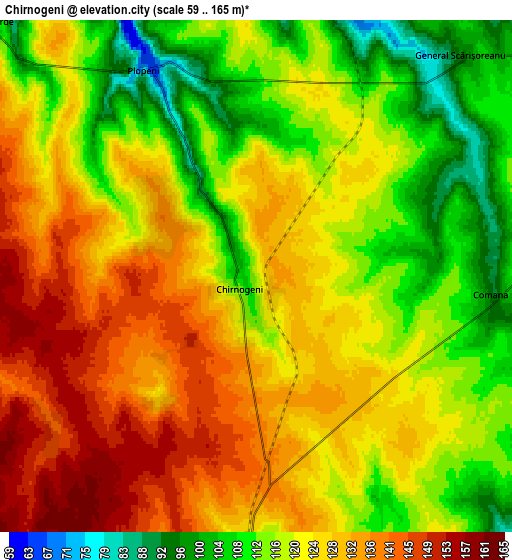
Below is the Elevation map of Chirnogeni, which displays elevation range with different colors. Scale of the first map is from 82 to 151 m (269 to 495 ft) with average elevation of 127.3 meters (=418 ft) [note 1]
These maps also provides idea of topography and contour of this city, they are displayed at different zoom levels. More info about maps, scale and edge coordinates you can find below images.
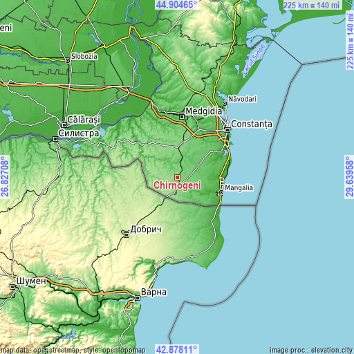
| \ | Map #1 | Map #2 | Topo.Map |
| Scale [m] | 82..151 m | 59..165 m | × |
| Scale [ft] | 269..495 ft | 194..541 ft | × |
| Average | 127.3 m = 418 ft | 122.9 m = 403 ft | × |
| Width | 7.04 km = 4.4 mi | 14.08 km = 8.7 mi | 225.3 km = 140 mi |
| Height | 7.04 km = 4.4 mi | 14.08 km = 8.7 mi | 225.3 km = 140 mi |
| ↑Max Latitude | 43.931656° | 43.963296° | 44.90465° |
| Latitude at center | 43.9° | 43.9° | 43.9° |
| ↓Min Latitude | 43.868327° | 43.836637° | 42.87811° |
| ← Min Longitude | 28.189385° | 28.145439° | 26.82708° |
| Longitude center | 28.23333° | 28.23333° | 28.23333° |
| →Max Longitude | 28.277275° | 28.321221° | 29.63958° |
Nearby cities:
Cities around Chirnogeni sort by population:
• Cobadin elevation 129 m
20.4 km,  356°
356°
• Negru Vodă 151 m
9.6 km,  196°
196°
• Mereni 99 m
19.8 km,  32°
32°
• Albeşti 48 m
18.4 km,  127°
127°
• Independenţa 155 m
14.1 km,  301°
301°
• Pecineaga 49 m
21.4 km,  90°
90°
• Amzacea 73 m
14.5 km,  67°
67°
• Comana 94 m
6.7 km, 90°
• Viișoara 136 m
20 km,  351°
351°
• Cerchezu 132 m
14.1 km,  229°
229°
• Plopeni 72 m
6.5 km,  331°
331°
• Dumbrăveni 132 m
20.4 km,  280°
280°
Multilingual:
 En español:
Chirnogeni elevación 118 m.
 En France:
Chirnogeni élévation 118 m.
 Auf Deutsch:
Chirnogeni höhe über dem Meeresspiegel ist 118 m.

Sources and notes:
- [note 1] Map square and city borders are not equal. Map elevation data is calculated only from area inside that square.
- [src 1] Elevation data from geonames database provided with same terms of usage.
- [src 2] The elevation map of Chirnogeni is generated using elevation data from NASA's 3 arcsec (90m) resolution SRTM data.
- [src 3] Base (background) map © OpenStreetMap contributors tiles are generated by Geofabrik and OpenTopoMap.
Copyright & License:
This Chirnogeni Elevation Map is licensed under CC BY-SA. You may reuse any part from this page, if you give a proper credit by linking to this URL:
 More info on terms of use page.