Câmpani elevation
Câmpani (Bihor, Comuna Câmpani), Romania elevation is 321 meters and Câmpani elevation in feet is 1053 ft above sea level [src 1]. Câmpani is a seat of a second-order administrative division (feature code) with elevation that is 69 meters (226 ft) bigger than average city elevation in Romania.
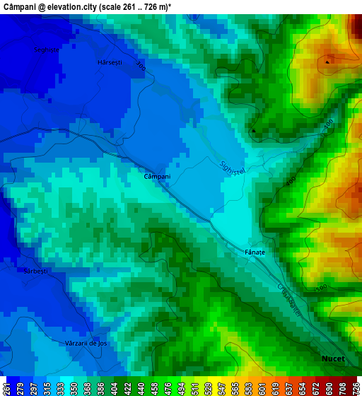
Below is the Elevation map of Câmpani, which displays elevation range with different colors. Scale of the first map is from 261 to 726 m (856 to 2382 ft) with average elevation of 376.9 meters (=1237 ft) [note 1]
These maps also provides idea of topography and contour of this city, they are displayed at different zoom levels. More info about maps, scale and edge coordinates you can find below images.
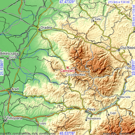
| \ | Map #1 | Topo.Map |
| Scale [m] | 261..726 m | × |
| Scale [ft] | 856..2382 ft | × |
| Average | 376.9 m = 1237 ft | × |
| Width | 6.73 km = 4.2 mi | 215.2 km = 133.7 mi |
| Height | 6.73 km = 4.2 mi | 215.2 km = 133.7 mi |
| ↑Max Latitude | 46.544384° | 47.47329° |
| Latitude at center | 46.51415° | 46.51415° |
| ↓Min Latitude | 46.4839° | 45.53778° |
| ← Min Longitude | 22.477915° | 21.11561° |
| Longitude center | 22.52186° | 22.52186° |
| →Max Longitude | 22.565805° | 23.92811° |
Nearby cities:
Cities around Câmpani sort by population:
• Ștei elevation 241 m
5.9 km,  291°
291°
• Bunteşti 239 m
12.2 km,  339°
339°
• Pietroasa 365 m
8 km,  15°
15°
• Rieni 238 m
8.9 km,  319°
319°
• Lunca 261 m
4.2 km,  273°
273°
• Drăgăneşti 204 m
15.6 km, 317°
• Vaşcău 448 m
6.8 km,  218°
218°
• Cărpinet 448 m
7.7 km,  202°
202°
• Lazuri de Beiuş 273 m
12.1 km,  309°
309°
• Nucet 392 m
4.1 km,  136°
136°
• Ghighișeni 233 m
8.1 km,  300°
300°
• Criştioru de Jos 391 m
10.6 km,  174°
174°
Multilingual:
 En español:
Câmpani elevación 321 m.
 En France:
Câmpani élévation 321 m.


Sources and notes:
- [note 1] Map square and city borders are not equal. Map elevation data is calculated only from area inside that square.
- [src 1] Elevation data from geonames database provided with same terms of usage.
- [src 2] The elevation map of Câmpani is generated using elevation data from NASA's 3 arcsec (90m) resolution SRTM data.
- [src 3] Base (background) map © OpenStreetMap contributors tiles are generated by Geofabrik and OpenTopoMap.
Copyright & License:
This Câmpani Elevation Map is licensed under CC BY-SA. You may reuse any part from this page, if you give a proper credit by linking to this URL:
 More info on terms of use page.