Câmpulung la Tisa elevation
Câmpulung la Tisa (Maramureş, Comuna Câmpulung la Tisa), Romania elevation is 244 meters and Câmpulung la Tisa elevation in feet is 801 ft above sea level [src 1]. Câmpulung la Tisa is a seat of a second-order administrative division (feature code) with elevation that is 8 meters (26 ft) smaller than average city elevation in Romania.
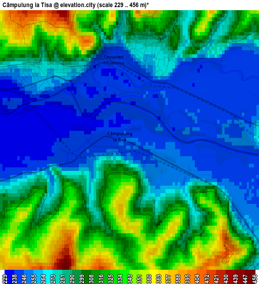
Below is the Elevation map of Câmpulung la Tisa, which displays elevation range with different colors. Scale of the first map is from 229 to 456 m (751 to 1496 ft) with average elevation of 286.8 meters (=941 ft) [note 1]
These maps also provides idea of topography and contour of this city, they are displayed at different zoom levels. More info about maps, scale and edge coordinates you can find below images.
| \ | Map #1 | Topo.Map |
| Scale [m] | 229..456 m | × |
| Scale [ft] | 751..1496 ft | × |
| Average | 286.8 m = 941 ft | × |
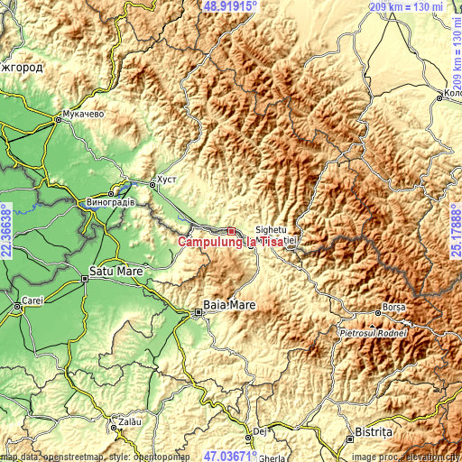
| Width | 6.54 km = 4.1 mi | 209.3 km = 130.1 mi |
| Height | 6.54 km = 4.1 mi | 209.3 km = 130.1 mi |
| ↑Max Latitude | 48.015914° | 48.91915° |
| Latitude at center | 47.98651° | 47.98651° |
| ↓Min Latitude | 47.957089° | 47.03671° |
| ← Min Longitude | 23.728685° | 22.36638° |
| Longitude center | 23.77263° | 23.77263° |
| →Max Longitude | 23.816575° | 25.17888° |
Nearby cities:
Cities around Câmpulung la Tisa sort by population:
• Sighetu Marmaţiei elevation 270 m
10.4 km,  125°
125°
• Bocicoiu Mare 297 m
17.1 km,  97°
97°
• Săpânţa 269 m
5.8 km,  247°
247°
• Remeţi 301 m
10.4 km,  268°
268°
• Vadu Izei 266 m
10.1 km, 125°
• Sarasău 257 m
5.4 km, 129°
• Vadu Izei 282 m
16.1 km, 132°
• Rona de Jos 305 m
19.8 km,  113°
113°
• Berbești 301 m
19.5 km,  141°
141°
• Iapa 338 m
7.9 km,  150°
150°
• Crăciunești 302 m
16 km, 102°
• Tisa 294 m
14.4 km, 107°
Multilingual:
 En español:
Câmpulung la Tisa elevación 244 m.
 En France:
Câmpulung la Tisa élévation 244 m.
 Auf Deutsch:
Câmpulung la Tisa höhe über dem Meeresspiegel ist 244 m.

Sources and notes:
- [note 1] Map square and city borders are not equal. Map elevation data is calculated only from area inside that square.
- [src 1] Elevation data from geonames database provided with same terms of usage.
- [src 2] The elevation map of Câmpulung la Tisa is generated using elevation data from NASA's 3 arcsec (90m) resolution SRTM data.
- [src 3] Base (background) map © OpenStreetMap contributors tiles are generated by Geofabrik and OpenTopoMap.
Copyright & License:
This Câmpulung la Tisa Elevation Map is licensed under CC BY-SA. You may reuse any part from this page, if you give a proper credit by linking to this URL:
 More info on terms of use page.