Ciorani elevation
Ciorani (Vrancea, Comuna Pufeşti), Romania elevation is 78 meters and Ciorani elevation in feet is 256 ft above sea level [src 1]. Ciorani is a populated place (feature code) with elevation that is 174 meters (571 ft) smaller than average city elevation in Romania.
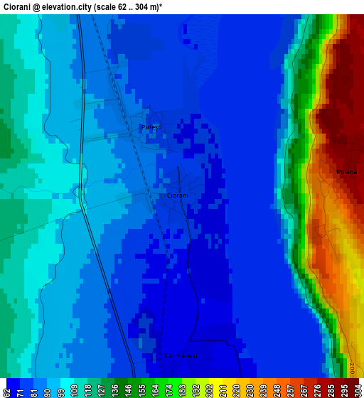
Below is the Elevation map of Ciorani, which displays elevation range with different colors. Scale of the first map is from 62 to 304 m (203 to 997 ft) with average elevation of 109.3 meters (=359 ft) [note 1]
These maps also provides idea of topography and contour of this city, they are displayed at different zoom levels. More info about maps, scale and edge coordinates you can find below images.
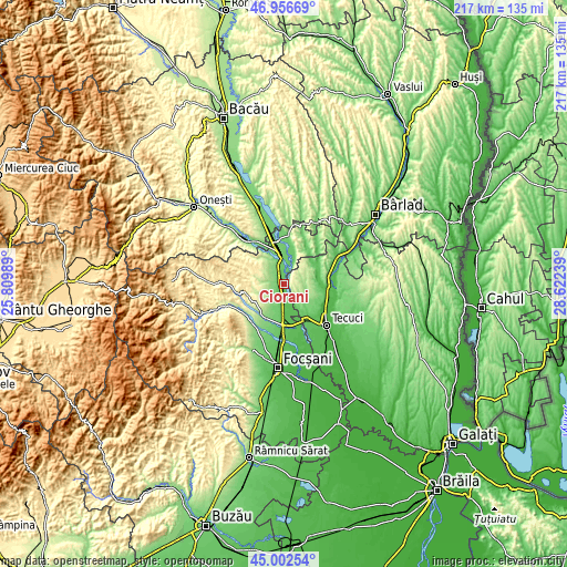
| \ | Map #1 | Topo.Map |
| Scale [m] | 62..304 m | × |
| Scale [ft] | 203..997 ft | × |
| Average | 109.3 m = 359 ft | × |
| Width | 6.79 km = 4.2 mi | 217.3 km = 135 mi |
| Height | 6.79 km = 4.2 mi | 217.3 km = 135 mi |
| ↑Max Latitude | 46.018765° | 46.95669° |
| Latitude at center | 45.98824° | 45.98824° |
| ↓Min Latitude | 45.957698° | 45.00254° |
| ← Min Longitude | 27.172195° | 25.80989° |
| Longitude center | 27.21614° | 27.21614° |
| →Max Longitude | 27.260085° | 28.62239° |
Nearby cities:
Cities around Ciorani sort by population:
• Mărășești elevation 58 m
11.7 km,  173°
173°
• Păuneşti 261 m
10.3 km,  299°
299°
• Nicoreşti 131 m
9.5 km,  131°
131°
• Rugineşti 239 m
11.6 km,  318°
318°
• Pufeşti 86 m
1.8 km, 316°
• Moviliţa 190 m
9.9 km,  244°
244°
• Buciumeni 203 m
6.6 km,  78°
78°
• Ploscuțeni 91 m
10.9 km,  22°
22°
• Ţepu 161 m
11.9 km,  101°
101°
• Poiana 288 m
3.1 km, 81°
• Domnești-Târg 98 m
4.1 km, 321°
• Viișoara 299 m
11.7 km,  307°
307°
Multilingual:
 En español:
Ciorani elevación 78 m.
 En France:
Ciorani élévation 78 m.


Sources and notes:
- [note 1] Map square and city borders are not equal. Map elevation data is calculated only from area inside that square.
- [src 1] Elevation data from geonames database provided with same terms of usage.
- [src 2] The elevation map of Ciorani is generated using elevation data from NASA's 3 arcsec (90m) resolution SRTM data.
- [src 3] Base (background) map © OpenStreetMap contributors tiles are generated by Geofabrik and OpenTopoMap.
Copyright & License:
This Ciorani Elevation Map is licensed under CC BY-SA. You may reuse any part from this page, if you give a proper credit by linking to this URL:
 More info on terms of use page.