Cârţa elevation
Cârţa (Harghita, Comuna Cârţa), Romania elevation is 735 meters and Cârţa elevation in feet is 2411 ft above sea level [src 1]. Cârţa is a seat of a second-order administrative division (feature code) with elevation that is 483 meters (1585 ft) bigger than average city elevation in Romania.
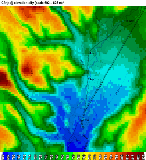
Below is the Elevation map of Cârţa, which displays elevation range with different colors. Scale of the first map is from 692 to 825 m (2270 to 2707 ft) with average elevation of 741.4 meters (=2432 ft) [note 1]
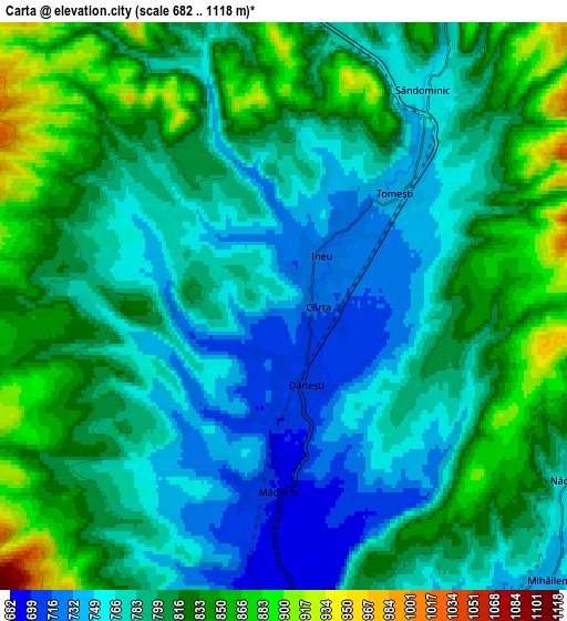
These maps also provides idea of topography and contour of this city, they are displayed at different zoom levels. More info about maps, scale and edge coordinates you can find below images.
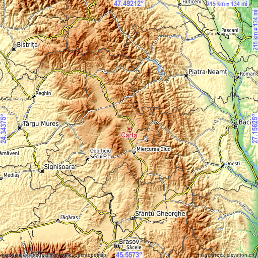
| \ | Map #1 | Map #2 | Topo.Map |
| Scale [m] | 692..825 m | 682..1118 m | × |
| Scale [ft] | 2270..2707 ft | 2238..3668 ft | × |
| Average | 741.4 m = 2432 ft | 798.7 m = 2620 ft | × |
| Width | 6.72 km = 4.2 mi | 13.45 km = 8.4 mi | 215.1 km = 133.7 mi |
| Height | 6.72 km = 4.2 mi | 13.45 km = 8.4 mi | 215.1 km = 133.7 mi |
| ↑Max Latitude | 46.563553° | 46.593759° | 47.49212° |
| Latitude at center | 46.53333° | 46.53333° | 46.53333° |
| ↓Min Latitude | 46.50309° | 46.472834° | 45.5573° |
| ← Min Longitude | 25.706055° | 25.662109° | 24.34375° |
| Longitude center | 25.75° | 25.75° | 25.75° |
| →Max Longitude | 25.793945° | 25.837891° | 27.15625° |
Nearby cities:
Cities around Cârţa sort by population:
• Bălan elevation 890 m
13.8 km,  18°
18°
• Siculeni 669 m
13 km,  180°
180°
• Sândominic 767 m
6.1 km, 22°
• Dăneşti 706 m
1.9 km, 180°
• Frumoasa 785 m
12 km,  140°
140°
• Tomești 734 m
3.4 km,  41°
41°
• Mihăileni 733 m
9 km,  145°
145°
• Ciceu 673 m
13.6 km,  169°
169°
• Mădăraș 698 m
4.3 km, 182°
• Ineu 722 m
1.7 km, 37°
• Racu 688 m
9.1 km, 174°
• Nicolești 788 m
12.7 km, 145°
Multilingual:
 En español:
Cârţa elevación 735 m.
 En France:
Cârţa élévation 735 m.


Sources and notes:
- [note 1] Map square and city borders are not equal. Map elevation data is calculated only from area inside that square.
- [src 1] Elevation data from geonames database provided with same terms of usage.
- [src 2] The elevation map of Cârţa is generated using elevation data from NASA's 3 arcsec (90m) resolution SRTM data.
- [src 3] Base (background) map © OpenStreetMap contributors tiles are generated by Geofabrik and OpenTopoMap.
Copyright & License:
This Cârţa Elevation Map is licensed under CC BY-SA. You may reuse any part from this page, if you give a proper credit by linking to this URL:
 More info on terms of use page.