Cogealac elevation
Cogealac (Constanța, Comuna Cogealac), Romania elevation is 94 meters and Cogealac elevation in feet is 308 ft above sea level [src 1]. Cogealac is a seat of a second-order administrative division (feature code) with elevation that is 158 meters (518 ft) smaller than average city elevation in Romania.
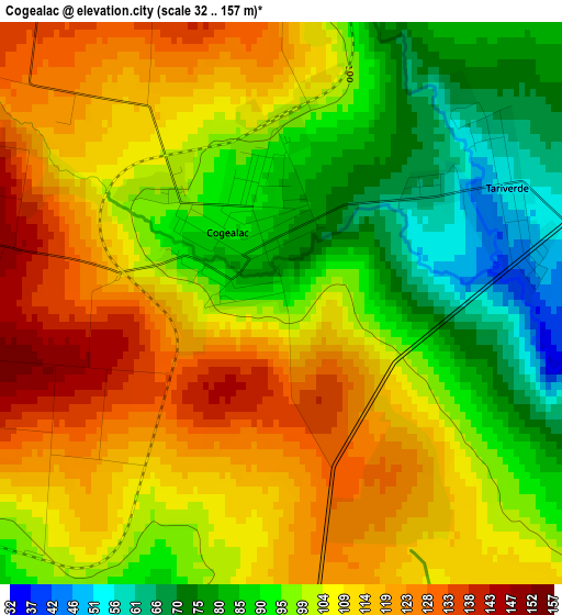
Below is the Elevation map of Cogealac, which displays elevation range with different colors. Scale of the first map is from 32 to 157 m (105 to 515 ft) with average elevation of 102.7 meters (=337 ft) [note 1]
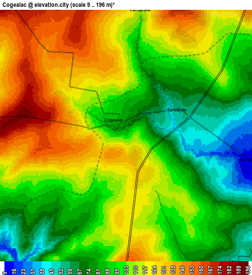
These maps also provides idea of topography and contour of this city, they are displayed at different zoom levels. More info about maps, scale and edge coordinates you can find below images.
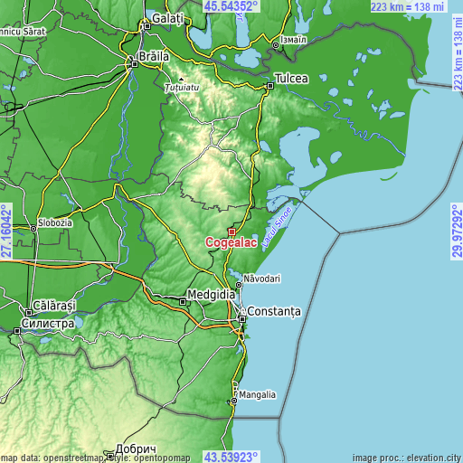
| \ | Map #1 | Map #2 | Topo.Map |
| Scale [m] | 32..157 m | 9..196 m | × |
| Scale [ft] | 105..515 ft | 30..643 ft | × |
| Average | 102.7 m = 337 ft | 104.6 m = 343 ft | × |
| Width | 6.96 km = 4.3 mi | 13.93 km = 8.7 mi | 222.9 km = 138.5 mi |
| Height | 6.96 km = 4.3 mi | 13.93 km = 8.7 mi | 222.8 km = 138.4 mi |
| ↑Max Latitude | 44.581309° | 44.612601° | 45.54352° |
| Latitude at center | 44.55° | 44.55° | 44.55° |
| ↓Min Latitude | 44.518674° | 44.487332° | 43.53923° |
| ← Min Longitude | 28.522725° | 28.478779° | 27.16042° |
| Longitude center | 28.56667° | 28.56667° | 28.56667° |
| →Max Longitude | 28.610615° | 28.654561° | 29.97292° |
Nearby cities:
Cities around Cogealac sort by population:
• Mihai Viteazu elevation 77 m
13.1 km,  44°
44°
• Târguşor 142 m
16.3 km,  226°
226°
• Istria 15 m
12 km,  81°
81°
• Săcele 43 m
9.9 km,  138°
138°
• Pantelimon de Jos 69 m
14.6 km,  277°
277°
• Beidaud 95 m
18.5 km,  0°
0°
• Fântânele 111 m
7 km,  6°
6°
• Piatra 6 m
16.1 km,  181°
181°
• Tariverde 54 m
3.2 km,  63°
63°
• Nuntași 13 m
6.7 km,  102°
102°
• Grădina 61 m
10.7 km,  273°
273°
• Pantelimon 143 m
18.7 km, 268°
Multilingual:
 En español:
Cogealac elevación 94 m.
 En France:
Cogealac élévation 94 m.


Sources and notes:
- [note 1] Map square and city borders are not equal. Map elevation data is calculated only from area inside that square.
- [src 1] Elevation data from geonames database provided with same terms of usage.
- [src 2] The elevation map of Cogealac is generated using elevation data from NASA's 3 arcsec (90m) resolution SRTM data.
- [src 3] Base (background) map © OpenStreetMap contributors tiles are generated by Geofabrik and OpenTopoMap.
Copyright & License:
This Cogealac Elevation Map is licensed under CC BY-SA. You may reuse any part from this page, if you give a proper credit by linking to this URL:
 More info on terms of use page.