Corni elevation
Corni (Botoşani, Comuna Corni), Romania elevation is 276 meters and Corni elevation in feet is 906 ft above sea level [src 1]. Corni is a seat of a second-order administrative division (feature code) with elevation that is 24 meters (79 ft) bigger than average city elevation in Romania.
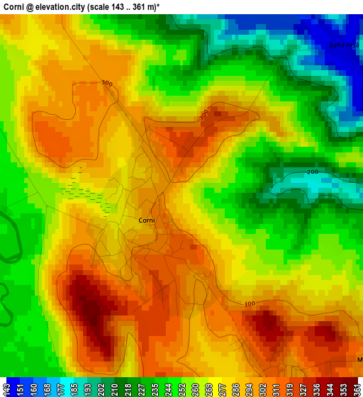
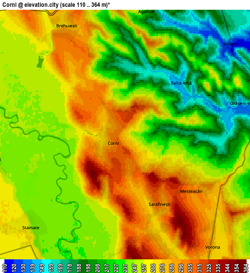
Below is the Elevation map of Corni, which displays elevation range with different colors. Scale of the first map is from 143 to 361 m (469 to 1184 ft) with average elevation of 268.6 meters (=881 ft) [note 1]
These maps also provides idea of topography and contour of this city, they are displayed at different zoom levels. More info about maps, scale and edge coordinates you can find below images.
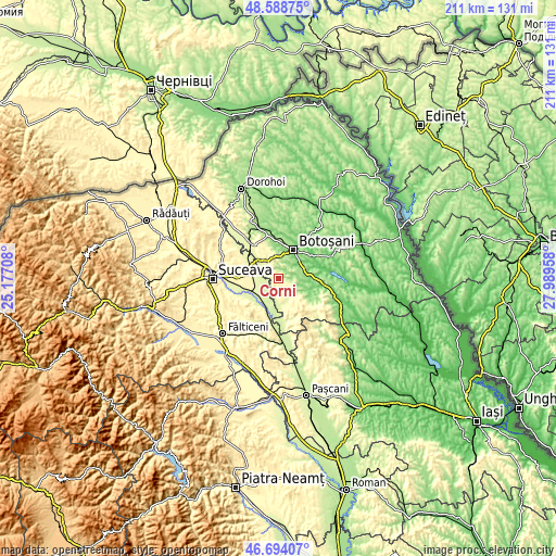
| \ | Map #1 | Map #2 | Topo.Map |
| Scale [m] | 143..361 m | 110..364 m | × |
| Scale [ft] | 469..1184 ft | 361..1194 ft | × |
| Average | 268.6 m = 881 ft | 249.4 m = 818 ft | × |
| Width | 6.58 km = 4.1 mi | 13.17 km = 8.2 mi | 210.7 km = 130.9 mi |
| Height | 6.58 km = 4.1 mi | 13.17 km = 8.2 mi | 210.7 km = 130.9 mi |
| ↑Max Latitude | 47.679596° | 47.709175° | 48.58875° |
| Latitude at center | 47.65° | 47.65° | 47.65° |
| ↓Min Latitude | 47.620388° | 47.590758° | 46.69407° |
| ← Min Longitude | 26.539385° | 26.495439° | 25.17708° |
| Longitude center | 26.58333° | 26.58333° | 26.58333° |
| →Max Longitude | 26.627275° | 26.671221° | 27.98958° |
Nearby cities:
Cities around Corni sort by population:
• Vlădeni elevation 273 m
8.9 km,  326°
326°
• Curteşti 143 m
8.9 km,  33°
33°
• Vorona 272 m
8.8 km,  156°
156°
• Corocăiești 265 m
7.7 km,  256°
256°
• Stamate 247 m
7 km,  225°
225°
• Sarafinești 307 m
4.1 km,  153°
153°
• Brehuiești 279 m
6.5 km, 333°
• Poiana 275 m
5.7 km, 160°
• Bursuceni 264 m
8.1 km,  270°
270°
• Icușeni 330 m
6.4 km,  171°
171°
• Bănești 258 m
8.1 km,  213°
213°
• Orășeni-Deal 186 m
7.6 km,  67°
67°
Multilingual:
 En español:
Corni elevación 276 m.
 En France:
Corni élévation 276 m.


Sources and notes:
- [note 1] Map square and city borders are not equal. Map elevation data is calculated only from area inside that square.
- [src 1] Elevation data from geonames database provided with same terms of usage.
- [src 2] The elevation map of Corni is generated using elevation data from NASA's 3 arcsec (90m) resolution SRTM data.
- [src 3] Base (background) map © OpenStreetMap contributors tiles are generated by Geofabrik and OpenTopoMap.
Copyright & License:
This Corni Elevation Map is licensed under CC BY-SA. You may reuse any part from this page, if you give a proper credit by linking to this URL:
 More info on terms of use page.