Crângurile de Sus elevation
Crângurile de Sus (Dâmboviţa, Comuna Valea Mare), Romania elevation is 209 meters and Crângurile de Sus elevation in feet is 686 ft above sea level [src 1]. Crângurile de Sus is a populated place (feature code) with elevation that is 43 meters (141 ft) smaller than average city elevation in Romania.
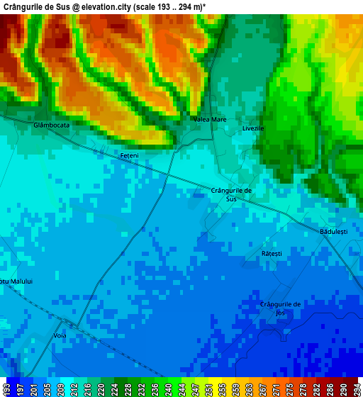
Below is the Elevation map of Crângurile de Sus, which displays elevation range with different colors. Scale of the first map is from 193 to 294 m (633 to 965 ft) with average elevation of 220.2 meters (=722 ft) [note 1]
These maps also provides idea of topography and contour of this city, they are displayed at different zoom levels. More info about maps, scale and edge coordinates you can find below images.
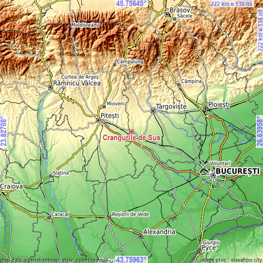
| \ | Map #1 | Topo.Map |
| Scale [m] | 193..294 m | × |
| Scale [ft] | 633..965 ft | × |
| Average | 220.2 m = 722 ft | × |
| Width | 6.94 km = 4.3 mi | 222 km = 137.9 mi |
| Height | 6.94 km = 4.3 mi | 222 km = 137.9 mi |
| ↑Max Latitude | 44.797862° | 45.75645° |
| Latitude at center | 44.76667° | 44.76667° |
| ↓Min Latitude | 44.735461° | 43.75963° |
| ← Min Longitude | 25.189385° | 23.82708° |
| Longitude center | 25.23333° | 25.23333° |
| →Max Longitude | 25.277275° | 26.63958° |
Nearby cities:
Cities around Crângurile de Sus sort by population:
• Găeşti elevation 186 m
8.6 km,  130°
130°
• Dragodana 184 m
9.9 km,  111°
111°
• Leordeni 224 m
9.4 km,  281°
281°
• Ludeşti 290 m
11.1 km,  0°
0°
• Hulubeşti 244 m
7.4 km, 0°
• Răteşti 226 m
8.7 km,  244°
244°
• Morteni 196 m
11.1 km,  180°
180°
• Valea Mare 248 m
1.9 km, 0°
• Gura Foii 199 m
4.4 km,  115°
115°
• Ionești 194 m
8.8 km,  156°
156°
• Pătuleni 214 m
6.6 km,  234°
234°
• Ciulnița 225 m
6.7 km,  290°
290°
Multilingual:
 En español:
Crângurile de Sus elevación 209 m.
 En France:
Crângurile de Sus élévation 209 m.
 Auf Deutsch:
Crângurile de Sus höhe über dem Meeresspiegel ist 209 m.

Sources and notes:
- [note 1] Map square and city borders are not equal. Map elevation data is calculated only from area inside that square.
- [src 1] Elevation data from geonames database provided with same terms of usage.
- [src 2] The elevation map of Crângurile de Sus is generated using elevation data from NASA's 3 arcsec (90m) resolution SRTM data.
- [src 3] Base (background) map © OpenStreetMap contributors tiles are generated by Geofabrik and OpenTopoMap.
Copyright & License:
This Crângurile de Sus Elevation Map is licensed under CC BY-SA. You may reuse any part from this page, if you give a proper credit by linking to this URL:
 More info on terms of use page.