Crivina elevation
Crivina (Prahova, Comuna Gorgota), Romania elevation is 107 meters and Crivina elevation in feet is 351 ft above sea level [src 1]. Crivina is a populated place (feature code) with elevation that is 145 meters (476 ft) smaller than average city elevation in Romania.
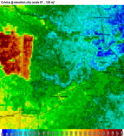
Below is the Elevation map of Crivina, which displays elevation range with different colors. Scale of the first map is from 97 to 128 m (318 to 420 ft) with average elevation of 108.6 meters (=356 ft) [note 1]
These maps also provides idea of topography and contour of this city, they are displayed at different zoom levels. More info about maps, scale and edge coordinates you can find below images.
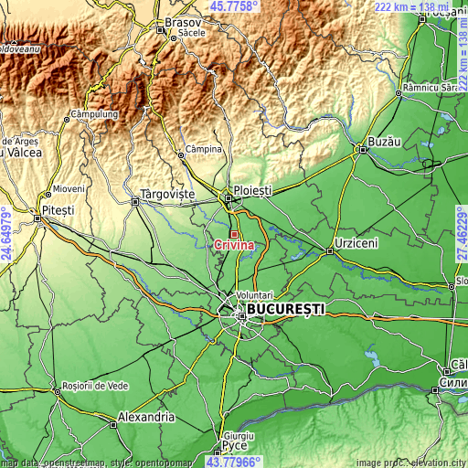
| \ | Map #1 | Topo.Map |
| Scale [m] | 97..128 m | × |
| Scale [ft] | 318..420 ft | × |
| Average | 108.6 m = 356 ft | × |
| Width | 6.94 km = 4.3 mi | 221.9 km = 137.9 mi |
| Height | 6.94 km = 4.3 mi | 221.9 km = 137.9 mi |
| ↑Max Latitude | 44.817541° | 45.7758° |
| Latitude at center | 44.78636° | 44.78636° |
| ↓Min Latitude | 44.755162° | 43.77966° |
| ← Min Longitude | 26.012095° | 24.64979° |
| Longitude center | 26.05604° | 26.05604° |
| →Max Longitude | 26.099985° | 27.46229° |
Nearby cities:
Cities around Crivina sort by population:
• Puchenii Mari elevation 103 m
4 km,  32°
32°
• Gorgota 110 m
2.2 km,  98°
98°
• Ciolpani 105 m
6.3 km,  159°
159°
• Tinosu 113 m
4.6 km,  317°
317°
• Pietroșani 101 m
7 km, 32°
• Tăriceni 123 m
6.9 km,  279°
279°
• Miroslăvești 102 m
3.1 km,  51°
51°
• Bătești 120 m
7 km,  349°
349°
• Poienarii Apostoli 112 m
1.6 km,  186°
186°
• Potigrafu 107 m
3.5 km,  92°
92°
• Puchenii Moșneni 103 m
3.8 km,  40°
40°
• Poienarii Burchii 113 m
5.1 km,  217°
217°
Multilingual:
 En español:
Crivina elevación 107 m.
 En France:
Crivina élévation 107 m.


Sources and notes:
- [note 1] Map square and city borders are not equal. Map elevation data is calculated only from area inside that square.
- [src 1] Elevation data from geonames database provided with same terms of usage.
- [src 2] The elevation map of Crivina is generated using elevation data from NASA's 3 arcsec (90m) resolution SRTM data.
- [src 3] Base (background) map © OpenStreetMap contributors tiles are generated by Geofabrik and OpenTopoMap.
Copyright & License:
This Crivina Elevation Map is licensed under CC BY-SA. You may reuse any part from this page, if you give a proper credit by linking to this URL:
 More info on terms of use page.