Cucueți elevation
Cucueți (Teleorman, Comuna Scrioaştea), Romania elevation is 104 meters and Cucueți elevation in feet is 341 ft above sea level [src 1]. Cucueți is a populated place (feature code) with elevation that is 148 meters (486 ft) smaller than average city elevation in Romania.
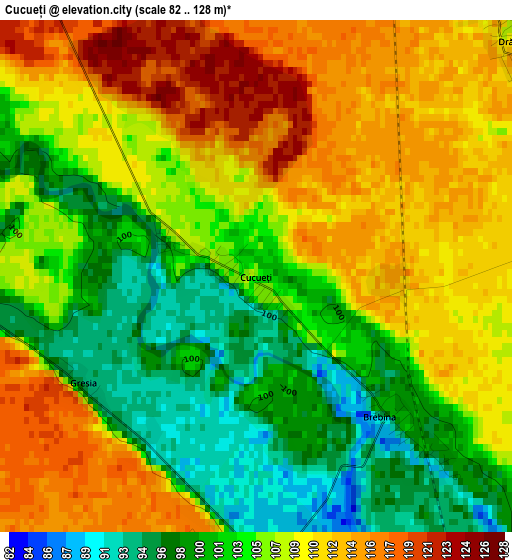
Below is the Elevation map of Cucueți, which displays elevation range with different colors. Scale of the first map is from 82 to 128 m (269 to 420 ft) with average elevation of 106.5 meters (=349 ft) [note 1]
These maps also provides idea of topography and contour of this city, they are displayed at different zoom levels. More info about maps, scale and edge coordinates you can find below images.
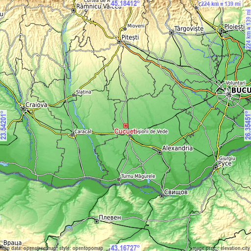
| \ | Map #1 | Topo.Map |
| Scale [m] | 82..128 m | × |
| Scale [ft] | 269..420 ft | × |
| Average | 106.5 m = 349 ft | × |
| Width | 7.01 km = 4.4 mi | 224.3 km = 139.4 mi |
| Height | 7.01 km = 4.4 mi | 224.2 km = 139.3 mi |
| ↑Max Latitude | 44.215825° | 45.18412° |
| Latitude at center | 44.18432° | 44.18432° |
| ↓Min Latitude | 44.152798° | 43.16727° |
| ← Min Longitude | 24.904315° | 23.54201° |
| Longitude center | 24.94826° | 24.94826° |
| →Max Longitude | 24.992205° | 26.35451° |
Nearby cities:
Cities around Cucueți sort by population:
• Roșiorii de Vede elevation 85 m
8 km,  159°
159°
• Măldăeni 97 m
7.6 km,  188°
188°
• Scrioaştea 91 m
3.8 km,  177°
177°
• Drăcşani 113 m
4.6 km,  37°
37°
• Stejaru 122 m
5.2 km,  268°
268°
• Drăgăneşti de Vede 86 m
9.9 km,  124°
124°
• Săceni 113 m
10.9 km,  59°
59°
• Merișani 115 m
9.5 km,  322°
322°
• Beuca 111 m
7.7 km,  10°
10°
• Socetu 126 m
7.6 km,  279°
279°
• Drăcșenei 115 m
5.6 km,  32°
32°
• Didești 105 m
6.3 km,  304°
304°
Multilingual:
 En español:
Cucueți elevación 104 m.
 En France:
Cucueți élévation 104 m.


Sources and notes:
- [note 1] Map square and city borders are not equal. Map elevation data is calculated only from area inside that square.
- [src 1] Elevation data from geonames database provided with same terms of usage.
- [src 2] The elevation map of Cucueți is generated using elevation data from NASA's 3 arcsec (90m) resolution SRTM data.
- [src 3] Base (background) map © OpenStreetMap contributors tiles are generated by Geofabrik and OpenTopoMap.
Copyright & License:
This Cucueți Elevation Map is licensed under CC BY-SA. You may reuse any part from this page, if you give a proper credit by linking to this URL:
 More info on terms of use page.