Cugir elevation
Cugir (Alba, Oraş Cugir), Romania elevation is 300 meters and Cugir elevation in feet is 984 ft above sea level [src 1]. Cugir is a seat of a second-order administrative division (feature code) with elevation that is 48 meters (157 ft) bigger than average city elevation in Romania.
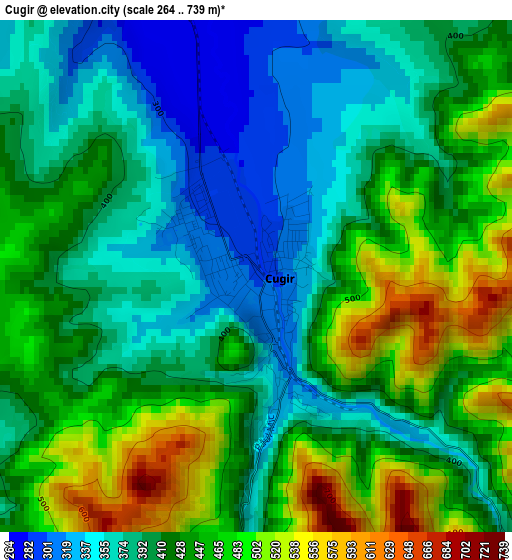
Below is the Elevation map of Cugir, which displays elevation range with different colors. Scale of the first map is from 264 to 739 m (866 to 2425 ft) with average elevation of 421.4 meters (=1383 ft) [note 1]
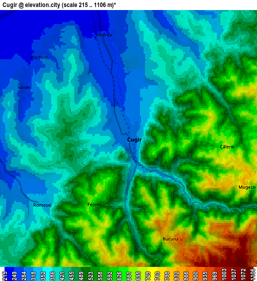
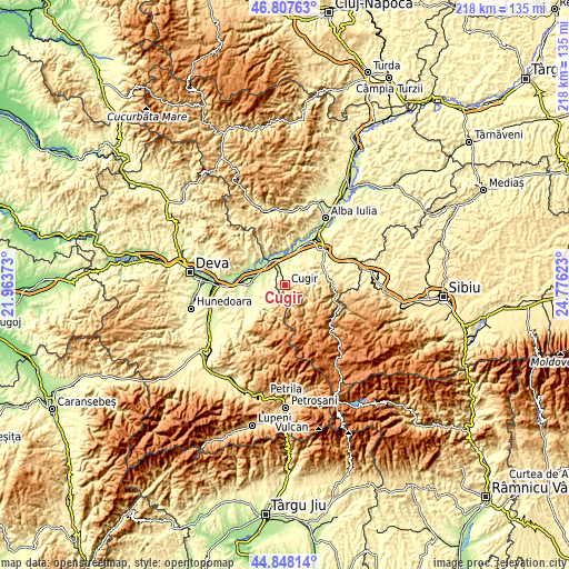
These maps also provides idea of topography and contour of this city, they are displayed at different zoom levels. More info about maps, scale and edge coordinates you can find below images.
| \ | Map #1 | Map #2 | Topo.Map |
| Scale [m] | 264..739 m | 215..1106 m | × |
| Scale [ft] | 866..2425 ft | 705..3629 ft | × |
| Average | 421.4 m = 1383 ft | 466.7 m = 1531 ft | × |
| Width | 6.81 km = 4.2 mi | 13.62 km = 8.5 mi | 217.9 km = 135.4 mi |
| Height | 6.81 km = 4.2 mi | 13.62 km = 8.5 mi | 217.9 km = 135.4 mi |
| ↑Max Latitude | 45.867119° | 45.89771° | 46.80763° |
| Latitude at center | 45.83651° | 45.83651° | 45.83651° |
| ↓Min Latitude | 45.805885° | 45.775242° | 44.84814° |
| ← Min Longitude | 23.326035° | 23.282089° | 21.96373° |
| Longitude center | 23.36998° | 23.36998° | 23.36998° |
| →Max Longitude | 23.413925° | 23.457871° | 24.77623° |
Nearby cities:
Cities around Cugir sort by population:
• Orăştie elevation 224 m
13.2 km,  268°
268°
• Beriu 260 m
15.6 km,  247°
247°
• Pianu de Sus 309 m
11.3 km,  51°
51°
• Romos 283 m
6.7 km, 266°
• Vinerea 250 m
5.7 km,  346°
346°
• Şibot 205 m
12.9 km, 347°
• Săliştea-Deal 327 m
7.4 km,  18°
18°
• Săliștea 251 m
8.2 km, 15°
• Căstău 245 m
12.5 km,  258°
258°
• Blândiana 260 m
15.9 km,  4°
4°
• Pianu de Jos 267 m
14.3 km,  40°
40°
• Pricaz 207 m
15.5 km,  279°
279°
Multilingual:
 En español:
Cugir elevación 300 m.
 En France:
Cugir élévation 300 m.


Sources and notes:
- [note 1] Map square and city borders are not equal. Map elevation data is calculated only from area inside that square.
- [src 1] Elevation data from geonames database provided with same terms of usage.
- [src 2] The elevation map of Cugir is generated using elevation data from NASA's 3 arcsec (90m) resolution SRTM data.
- [src 3] Base (background) map © OpenStreetMap contributors tiles are generated by Geofabrik and OpenTopoMap.
Copyright & License:
This Cugir Elevation Map is licensed under CC BY-SA. You may reuse any part from this page, if you give a proper credit by linking to this URL:
 More info on terms of use page.