Dej elevation
Dej (Cluj, Municipiul Dej), Romania elevation is 231 meters and Dej elevation in feet is 758 ft above sea level [src 1]. Dej is a seat of a second-order administrative division (feature code) with elevation that is 21 meters (69 ft) smaller than average city elevation in Romania.
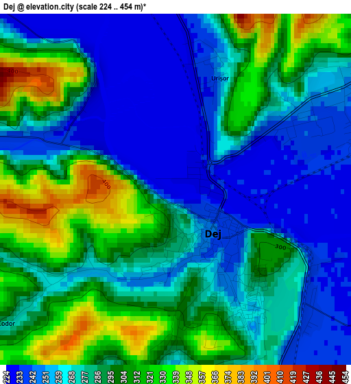
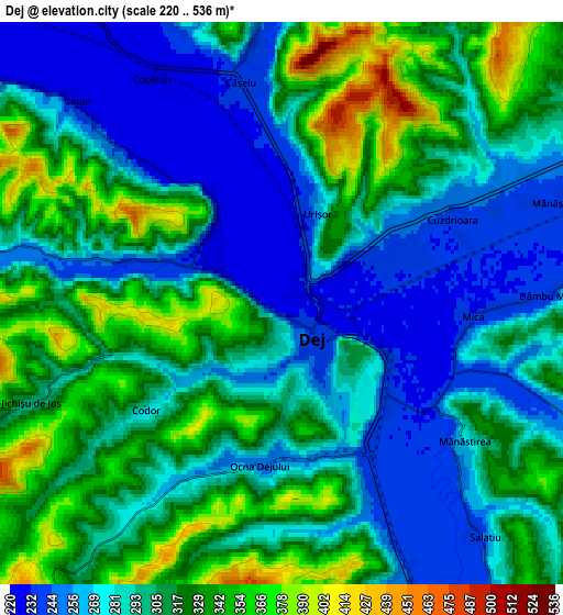
Below is the Elevation map of Dej, which displays elevation range with different colors. Scale of the first map is from 224 to 454 m (735 to 1490 ft) with average elevation of 280.8 meters (=921 ft) [note 1]
These maps also provides idea of topography and contour of this city, they are displayed at different zoom levels. More info about maps, scale and edge coordinates you can find below images.
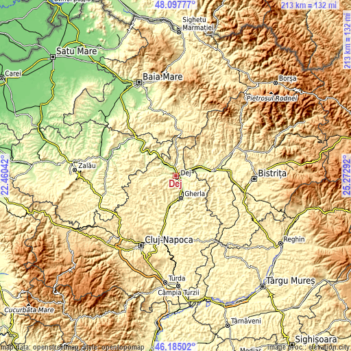
| \ | Map #1 | Map #2 | Topo.Map |
| Scale [m] | 224..454 m | 220..536 m | × |
| Scale [ft] | 735..1490 ft | 722..1759 ft | × |
| Average | 280.8 m = 921 ft | 300.2 m = 985 ft | × |
| Width | 6.65 km = 4.1 mi | 13.29 km = 8.3 mi | 212.7 km = 132.2 mi |
| Height | 6.65 km = 4.1 mi | 13.29 km = 8.3 mi | 212.7 km = 132.2 mi |
| ↑Max Latitude | 47.179878° | 47.209739° | 48.09777° |
| Latitude at center | 47.15° | 47.15° | 47.15° |
| ↓Min Latitude | 47.120105° | 47.090194° | 46.18502° |
| ← Min Longitude | 23.822725° | 23.778779° | 22.46042° |
| Longitude center | 23.86667° | 23.86667° | 23.86667° |
| →Max Longitude | 23.910615° | 23.954561° | 25.27292° |
Nearby cities:
Cities around Dej sort by population:
• Căşeiu elevation 239 m
3.7 km,  0°
0°
• Mica 234 m
5.4 km,  110°
110°
• Reteag 250 m
12.6 km,  66°
66°
• Ocna Dejului 253 m
3.8 km,  188°
188°
• Vad 428 m
10.4 km,  302°
302°
• Cuzdrioara 235 m
4.2 km,  63°
63°
• Jichişu de Jos 332 m
6.3 km,  233°
233°
• Nireș 256 m
9.5 km, 114°
• Sânmărghita 242 m
9.7 km,  85°
85°
• Rugășești 262 m
9.1 km, 3°
• Ciceu-Mihăiești 250 m
9.1 km, 64°
• Câţcău 221 m
8.4 km,  311°
311°
Multilingual:
 En español:
Dej elevación 231 m.
 En France:
Dej élévation 231 m.


Sources and notes:
- [note 1] Map square and city borders are not equal. Map elevation data is calculated only from area inside that square.
- [src 1] Elevation data from geonames database provided with same terms of usage.
- [src 2] The elevation map of Dej is generated using elevation data from NASA's 3 arcsec (90m) resolution SRTM data.
- [src 3] Base (background) map © OpenStreetMap contributors tiles are generated by Geofabrik and OpenTopoMap.
Copyright & License:
This Dej Elevation Map is licensed under CC BY-SA. You may reuse any part from this page, if you give a proper credit by linking to this URL:
 More info on terms of use page.