Dobrița elevation
Dobrița (Gorj, Comuna Runcu), Romania elevation is 401 meters and Dobrița elevation in feet is 1316 ft above sea level [src 1]. Dobrița is a populated place (feature code) with elevation that is 149 meters (489 ft) bigger than average city elevation in Romania.
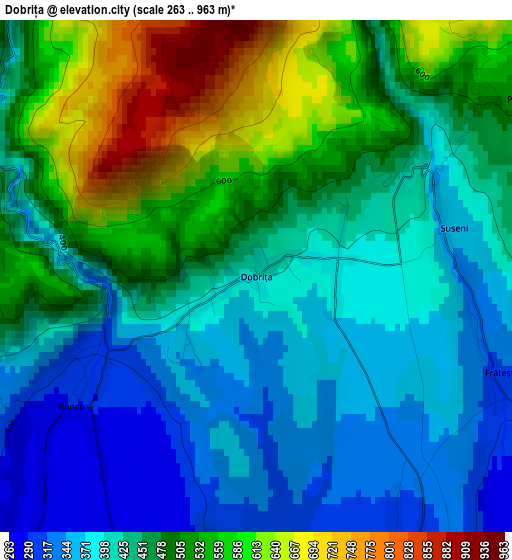
Below is the Elevation map of Dobrița, which displays elevation range with different colors. Scale of the first map is from 263 to 963 m (863 to 3159 ft) with average elevation of 457 meters (=1499 ft) [note 1]
These maps also provides idea of topography and contour of this city, they are displayed at different zoom levels. More info about maps, scale and edge coordinates you can find below images.
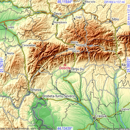
| \ | Map #1 | Topo.Map |
| Scale [m] | 263..963 m | × |
| Scale [ft] | 863..3159 ft | × |
| Average | 457 m = 1499 ft | × |
| Width | 6.89 km = 4.3 mi | 220.6 km = 137.1 mi |
| Height | 6.89 km = 4.3 mi | 220.6 km = 137.1 mi |
| ↑Max Latitude | 45.166032° | 46.11844° |
| Latitude at center | 45.13504° | 45.13504° |
| ↓Min Latitude | 45.104031° | 44.13439° |
| ← Min Longitude | 23.130115° | 21.76781° |
| Longitude center | 23.17406° | 23.17406° |
| →Max Longitude | 23.218005° | 24.58031° |
Nearby cities:
Cities around Dobrița sort by population:
• Târgu Jiu elevation 212 m
12.8 km,  137°
137°
• Băleşti 183 m
13.6 km,  165°
165°
• Runcu 282 m
3.8 km,  237°
237°
• Peştişani 245 m
13.4 km, 235°
• Stăneşti 297 m
6.3 km,  108°
108°
• Turcineşti 243 m
13.1 km, 107°
• Ceauru 180 m
13.9 km, 170°
• Leleşti 298 m
4.4 km,  152°
152°
• Arcani 239 m
6.6 km,  209°
209°
• Bâlta 332 m
6 km,  251°
251°
• Valea Mare 344 m
7.8 km, 251°
• Sâmbotin 279 m
12.5 km,  90°
90°
Multilingual:
 En español:
Dobrița elevación 401 m.
 En France:
Dobrița élévation 401 m.


Sources and notes:
- [note 1] Map square and city borders are not equal. Map elevation data is calculated only from area inside that square.
- [src 1] Elevation data from geonames database provided with same terms of usage.
- [src 2] The elevation map of Dobrița is generated using elevation data from NASA's 3 arcsec (90m) resolution SRTM data.
- [src 3] Base (background) map © OpenStreetMap contributors tiles are generated by Geofabrik and OpenTopoMap.
Copyright & License:
This Dobrița Elevation Map is licensed under CC BY-SA. You may reuse any part from this page, if you give a proper credit by linking to this URL:
 More info on terms of use page.