Doftana elevation
Doftana (Prahova, Comuna Telega), Romania elevation is 517 meters and Doftana elevation in feet is 1696 ft above sea level [src 1]. Doftana is a populated place (feature code) with elevation that is 265 meters (869 ft) bigger than average city elevation in Romania.
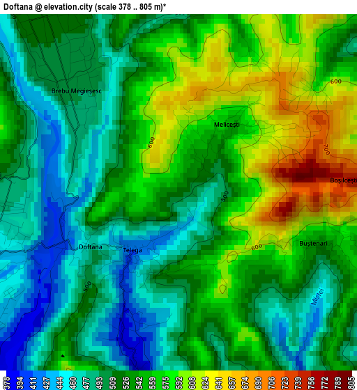
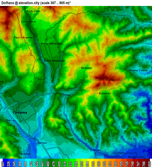
Below is the Elevation map of Doftana, which displays elevation range with different colors. Scale of the first map is from 378 to 805 m (1240 to 2641 ft) with average elevation of 531.9 meters (=1745 ft) [note 1]
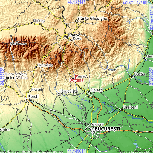
These maps also provides idea of topography and contour of this city, they are displayed at different zoom levels. More info about maps, scale and edge coordinates you can find below images.
| \ | Map #1 | Map #2 | Topo.Map |
| Scale [m] | 378..805 m | 307..805 m | × |
| Scale [ft] | 1240..2641 ft | 1007..2641 ft | × |
| Average | 531.9 m = 1745 ft | 497 m = 1631 ft | × |
| Width | 6.89 km = 4.3 mi | 13.78 km = 8.6 mi | 220.5 km = 137 mi |
| Height | 6.89 km = 4.3 mi | 13.78 km = 8.6 mi | 220.5 km = 137 mi |
| ↑Max Latitude | 45.180984° | 45.211951° | 46.13314° |
| Latitude at center | 45.15° | 45.15° | 45.15° |
| ↓Min Latitude | 45.118999° | 45.087981° | 44.14961° |
| ← Min Longitude | 25.756055° | 25.712109° | 24.39375° |
| Longitude center | 25.8° | 25.8° | 25.8° |
| →Max Longitude | 25.843945° | 25.887891° | 27.20625° |
Nearby cities:
Cities around Doftana sort by population:
• Câmpina elevation 443 m
5.7 km,  242°
242°
• Brebu Mânăstirei 525 m
4.5 km,  324°
324°
• Telega 436 m
2.3 km,  215°
215°
• Scorţeni 410 m
6.8 km,  144°
144°
• Băneşti 401 m
6.1 km,  205°
205°
• Aluniş 410 m
7.6 km,  43°
43°
• Cornu de Jos 496 m
7.5 km,  275°
275°
• Brebu Megieșesc 496 m
2.8 km,  314°
314°
• Urleta 400 m
7 km,  184°
184°
• Mislea 358 m
6.2 km,  162°
162°
• Pietriceaua 671 m
7.7 km,  5°
5°
• Cosmina de Jos 522 m
6.5 km,  90°
90°
Multilingual:
 En español:
Doftana elevación 517 m.
 En France:
Doftana élévation 517 m.


Sources and notes:
- [note 1] Map square and city borders are not equal. Map elevation data is calculated only from area inside that square.
- [src 1] Elevation data from geonames database provided with same terms of usage.
- [src 2] The elevation map of Doftana is generated using elevation data from NASA's 3 arcsec (90m) resolution SRTM data.
- [src 3] Base (background) map © OpenStreetMap contributors tiles are generated by Geofabrik and OpenTopoMap.
Copyright & License:
This Doftana Elevation Map is licensed under CC BY-SA. You may reuse any part from this page, if you give a proper credit by linking to this URL:
 More info on terms of use page.