Dragosloveni elevation
Dragosloveni (Vrancea, Comuna Soveja), Romania elevation is 518 meters and Dragosloveni elevation in feet is 1699 ft above sea level [src 1]. Dragosloveni is a populated place (feature code) with elevation that is 266 meters (873 ft) bigger than average city elevation in Romania.
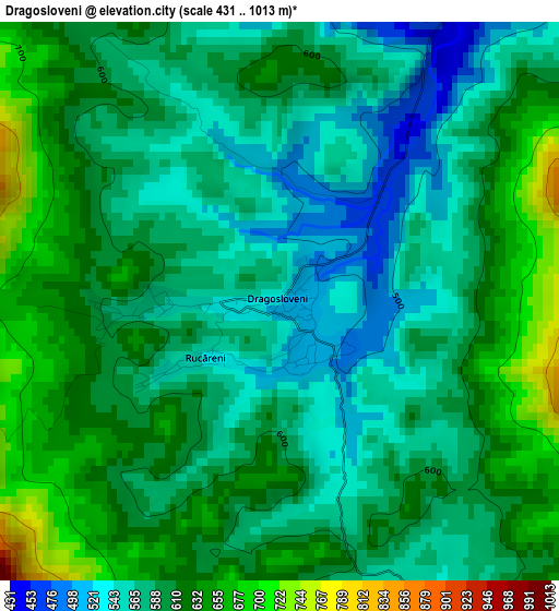
Below is the Elevation map of Dragosloveni, which displays elevation range with different colors. Scale of the first map is from 431 to 1013 m (1414 to 3323 ft) with average elevation of 595.9 meters (=1955 ft) [note 1]
These maps also provides idea of topography and contour of this city, they are displayed at different zoom levels. More info about maps, scale and edge coordinates you can find below images.
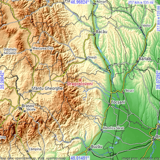
| \ | Map #1 | Topo.Map |
| Scale [m] | 431..1013 m | × |
| Scale [ft] | 1414..3323 ft | × |
| Average | 595.9 m = 1955 ft | × |
| Width | 6.79 km = 4.2 mi | 217.2 km = 135 mi |
| Height | 6.79 km = 4.2 mi | 217.2 km = 135 mi |
| ↑Max Latitude | 46.030519° | 46.96824° |
| Latitude at center | 46° | 46° |
| ↓Min Latitude | 45.969465° | 45.01451° |
| ← Min Longitude | 26.622725° | 25.26042° |
| Longitude center | 26.66667° | 26.66667° |
| →Max Longitude | 26.710615° | 28.07292° |
Nearby cities:
Cities around Dragosloveni sort by population:
• Tulnici elevation 546 m
9.3 km,  180°
180°
• Vizantea-Mânăstirească 365 m
9.2 km,  101°
101°
• Câmpurile de Jos 364 m
9.2 km,  78°
78°
• Răcoasa 372 m
16.7 km,  90°
90°
• Câmpuri 361 m
9.5 km, 79°
• Negrilești 491 m
7.6 km,  156°
156°
• Mătăcina 378 m
16.6 km,  141°
141°
• Păulești 463 m
12.2 km,  171°
171°
• Rucăreni 538 m
1.1 km,  235°
235°
• Valea Sării 353 m
17.1 km, 143°
• Mânăstirea Caşin 352 m
16.7 km,  4°
4°
• Bârseşti 423 m
10.6 km,  150°
150°
Multilingual:
 En español:
Dragosloveni elevación 518 m.
 En France:
Dragosloveni élévation 518 m.
 Auf Deutsch:
Dragosloveni höhe über dem Meeresspiegel ist 518 m.

Sources and notes:
- [note 1] Map square and city borders are not equal. Map elevation data is calculated only from area inside that square.
- [src 1] Elevation data from geonames database provided with same terms of usage.
- [src 2] The elevation map of Dragosloveni is generated using elevation data from NASA's 3 arcsec (90m) resolution SRTM data.
- [src 3] Base (background) map © OpenStreetMap contributors tiles are generated by Geofabrik and OpenTopoMap.
Copyright & License:
This Dragosloveni Elevation Map is licensed under CC BY-SA. You may reuse any part from this page, if you give a proper credit by linking to this URL:
 More info on terms of use page.