Fântânele elevation
Fântânele (Dâmboviţa, Comuna Cojasca), Romania elevation is 130 meters and Fântânele elevation in feet is 427 ft above sea level [src 1]. Fântânele is a populated place (feature code) with elevation that is 122 meters (400 ft) smaller than average city elevation in Romania.
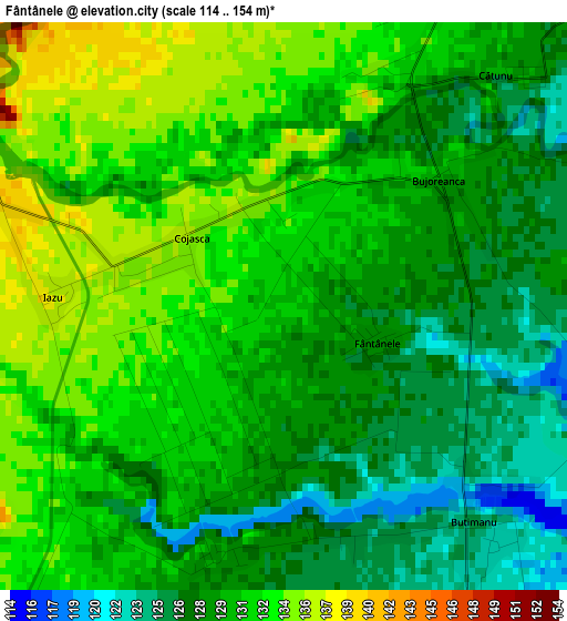
Below is the Elevation map of Fântânele, which displays elevation range with different colors. Scale of the first map is from 114 to 154 m (374 to 505 ft) with average elevation of 130 meters (=427 ft) [note 1]
These maps also provides idea of topography and contour of this city, they are displayed at different zoom levels. More info about maps, scale and edge coordinates you can find below images.
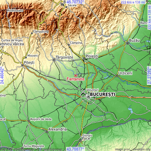
| \ | Map #1 | Topo.Map |
| Scale [m] | 114..154 m | × |
| Scale [ft] | 374..505 ft | × |
| Average | 130 m = 427 ft | × |
| Width | 6.94 km = 4.3 mi | 222.2 km = 138.1 mi |
| Height | 6.94 km = 4.3 mi | 222.2 km = 138.1 mi |
| ↑Max Latitude | 44.747889° | 45.70732° |
| Latitude at center | 44.71667° | 44.71667° |
| ↓Min Latitude | 44.685434° | 43.70877° |
| ← Min Longitude | 25.822725° | 24.46042° |
| Longitude center | 25.86667° | 25.86667° |
| →Max Longitude | 25.910615° | 27.27292° |
Nearby cities:
Cities around Fântânele sort by population:
• Corneşti elevation 141 m
7.4 km,  0°
0°
• Cojasca 133 m
1.3 km,  270°
270°
• Niculești 116 m
7.1 km,  122°
122°
• Butimanu 121 m
4.5 km,  144°
144°
• Iazu 137 m
2.8 km, 272°
• Ologeni 120 m
6.9 km,  74°
74°
• Bilciureşti 143 m
5.6 km,  289°
289°
• Buriaș 119 m
9.2 km,  78°
78°
• Ciocănari 112 m
9 km,  103°
103°
• Suseni Socetu 148 m
7 km,  309°
309°
• Ibrianu 144 m
6.7 km,  344°
344°
• Vizurești 126 m
9.7 km,  208°
208°
Multilingual:
 En español:
Fântânele elevación 130 m.
 En France:
Fântânele élévation 130 m.
 Auf Deutsch:
Fântânele höhe über dem Meeresspiegel ist 130 m.

Sources and notes:
- [note 1] Map square and city borders are not equal. Map elevation data is calculated only from area inside that square.
- [src 1] Elevation data from geonames database provided with same terms of usage.
- [src 2] The elevation map of Fântânele is generated using elevation data from NASA's 3 arcsec (90m) resolution SRTM data.
- [src 3] Base (background) map © OpenStreetMap contributors tiles are generated by Geofabrik and OpenTopoMap.
Copyright & License:
This Fântânele Elevation Map is licensed under CC BY-SA. You may reuse any part from this page, if you give a proper credit by linking to this URL:
 More info on terms of use page.