Fundata elevation
Fundata (Braşov, Comuna Fundata), Romania elevation is 1265 meters and Fundata elevation in feet is 4150 ft above sea level [src 1]. Fundata is a seat of a second-order administrative division (feature code) with elevation that is 1013 meters (3323 ft) bigger than average city elevation in Romania.
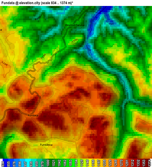
Below is the Elevation map of Fundata, which displays elevation range with different colors. Scale of the first map is from 834 to 1374 m (2736 to 4508 ft) with average elevation of 1139.3 meters (=3738 ft) [note 1]
These maps also provides idea of topography and contour of this city, they are displayed at different zoom levels. More info about maps, scale and edge coordinates you can find below images.
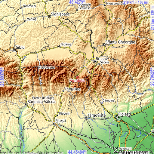
| \ | Map #1 | Topo.Map |
| Scale [m] | 834..1374 m | × |
| Scale [ft] | 2736..4508 ft | × |
| Average | 1139.3 m = 3738 ft | × |
| Width | 6.86 km = 4.3 mi | 219.4 km = 136.3 mi |
| Height | 6.86 km = 4.3 mi | 219.4 km = 136.3 mi |
| ↑Max Latitude | 45.480821° | 46.4279° |
| Latitude at center | 45.45° | 45.45° |
| ↓Min Latitude | 45.419163° | 44.45484° |
| ← Min Longitude | 25.256055° | 23.89375° |
| Longitude center | 25.3° | 25.3° |
| →Max Longitude | 25.343945° | 26.70625° |
Nearby cities:
Cities around Fundata sort by population:
• Zărnești elevation 716 m
12.4 km,  6°
6°
• Rucăr 774 m
11.8 km,  241°
241°
• Bran 1017 m
8.4 km,  27°
27°
• Moeciu de Jos 862 m
3.9 km,  19°
19°
• Poiana Mărului (Brașov) 751 m
16.7 km,  0°
0°
• Valea Caselor 690 m
15.2 km,  223°
223°
• Dragoslavele 675 m
15.3 km, 221°
• Moieciu de Jos 787 m
6.6 km, 26°
• Sohodol 752 m
11.8 km,  42°
42°
• Tohanu Nou 692 m
13.2 km, 30°
• Șimon 852 m
5.9 km,  48°
48°
• Dâmbovicioara 1090 m
5.2 km,  270°
270°
Multilingual:
 En español:
Fundata elevación 1265 m.
 En France:
Fundata élévation 1265 m.
 Auf Deutsch:
Fundata höhe über dem Meeresspiegel ist 1265 m.

Sources and notes:
- [note 1] Map square and city borders are not equal. Map elevation data is calculated only from area inside that square.
- [src 1] Elevation data from geonames database provided with same terms of usage.
- [src 2] The elevation map of Fundata is generated using elevation data from NASA's 3 arcsec (90m) resolution SRTM data.
- [src 3] Base (background) map © OpenStreetMap contributors tiles are generated by Geofabrik and OpenTopoMap.
Copyright & License:
This Fundata Elevation Map is licensed under CC BY-SA. You may reuse any part from this page, if you give a proper credit by linking to this URL:
 More info on terms of use page.