Găneasa elevation
Găneasa (Ilfov, Comuna Găneasa), Romania elevation is 81 meters and Găneasa elevation in feet is 266 ft above sea level [src 1]. Găneasa is a seat of a second-order administrative division (feature code) with elevation that is 171 meters (561 ft) smaller than average city elevation in Romania.
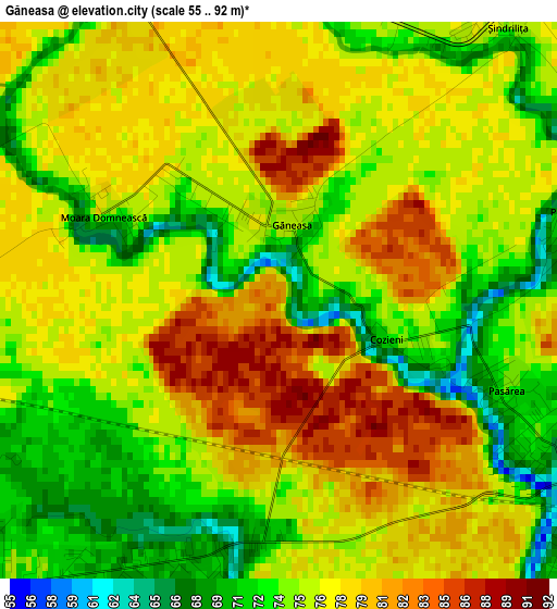
Below is the Elevation map of Găneasa, which displays elevation range with different colors. Scale of the first map is from 55 to 92 m (180 to 302 ft) with average elevation of 76 meters (=249 ft) [note 1]
These maps also provides idea of topography and contour of this city, they are displayed at different zoom levels. More info about maps, scale and edge coordinates you can find below images.
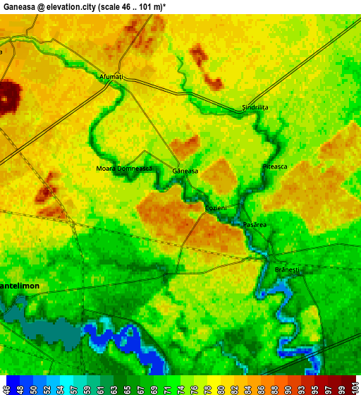
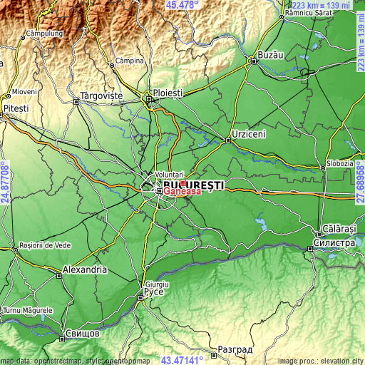
| \ | Map #1 | Map #2 | Topo.Map |
| Scale [m] | 55..92 m | 46..101 m | × |
| Scale [ft] | 180..302 ft | 151..331 ft | × |
| Average | 76 m = 249 ft | 75.2 m = 247 ft | × |
| Width | 6.97 km = 4.3 mi | 13.94 km = 8.7 mi | 223.1 km = 138.6 mi |
| Height | 6.97 km = 4.3 mi | 13.94 km = 8.7 mi | 223.1 km = 138.6 mi |
| ↑Max Latitude | 44.514675° | 44.546002° | 45.478° |
| Latitude at center | 44.48333° | 44.48333° | 44.48333° |
| ↓Min Latitude | 44.451969° | 44.42059° | 43.47141° |
| ← Min Longitude | 26.239385° | 26.195439° | 24.87708° |
| Longitude center | 26.28333° | 26.28333° | 26.28333° |
| →Max Longitude | 26.327275° | 26.371221° | 27.68958° |
Nearby cities:
Cities around Găneasa sort by population:
• Voluntari elevation 82 m
8.8 km,  274°
274°
• Pantelimon 72 m
7.6 km,  240°
240°
• Cernica 60 m
7.4 km,  180°
180°
• Brăneşti 53 m
5.4 km,  133°
133°
• Afumaţi 79 m
3.9 km,  340°
340°
• Dobroeşti 72 m
8.8 km, 244°
• Ştefăneştii de Jos 84 m
8.6 km,  310°
310°
• Fundeni 76 m
9.7 km,  253°
253°
• Tânganu 57 m
8.9 km,  164°
164°
• Piteasca 76 m
3.9 km,  73°
73°
• Islaz 70 m
8.6 km,  106°
106°
• Căldăraru 65 m
8 km,  191°
191°
Multilingual:
 En español:
Găneasa elevación 81 m.
 En France:
Găneasa élévation 81 m.


Sources and notes:
- [note 1] Map square and city borders are not equal. Map elevation data is calculated only from area inside that square.
- [src 1] Elevation data from geonames database provided with same terms of usage.
- [src 2] The elevation map of Găneasa is generated using elevation data from NASA's 3 arcsec (90m) resolution SRTM data.
- [src 3] Base (background) map © OpenStreetMap contributors tiles are generated by Geofabrik and OpenTopoMap.
Copyright & License:
This Găneasa Elevation Map is licensed under CC BY-SA. You may reuse any part from this page, if you give a proper credit by linking to this URL:
 More info on terms of use page.