Ghinești elevation
Ghinești (Dâmboviţa, Comuna Sălcioara), Romania elevation is 188 meters and Ghinești elevation in feet is 617 ft above sea level [src 1]. Ghinești is a populated place (feature code) with elevation that is 64 meters (210 ft) smaller than average city elevation in Romania.
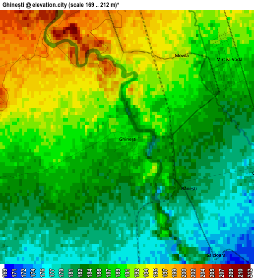
Below is the Elevation map of Ghinești, which displays elevation range with different colors. Scale of the first map is from 169 to 212 m (554 to 696 ft) with average elevation of 187.3 meters (=615 ft) [note 1]
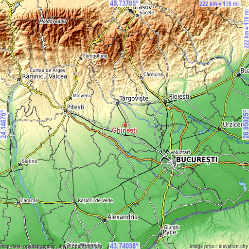
These maps also provides idea of topography and contour of this city, they are displayed at different zoom levels. More info about maps, scale and edge coordinates you can find below images.
| \ | Map #1 | Topo.Map |
| Scale [m] | 169..212 m | × |
| Scale [ft] | 554..696 ft | × |
| Average | 187.3 m = 615 ft | × |
| Width | 6.94 km = 4.3 mi | 222.1 km = 138 mi |
| Height | 6.94 km = 4.3 mi | 222.1 km = 138 mi |
| ↑Max Latitude | 44.778942° | 45.73785° |
| Latitude at center | 44.74774° | 44.74774° |
| ↓Min Latitude | 44.716521° | 43.74038° |
| ← Min Longitude | 25.509055° | 24.14675° |
| Longitude center | 25.553° | 25.553° |
| →Max Longitude | 25.596945° | 26.95925° |
Nearby cities:
Cities around Ghinești sort by population:
• Gura Şuţii elevation 192 m
2.9 km,  275°
275°
• Braniştea 164 m
7.6 km,  161°
161°
• Nucet 207 m
4 km,  356°
356°
• Sălcioara 175 m
4.2 km,  145°
145°
• Produleşti 172 m
6.8 km,  218°
218°
• Perșinari 231 m
7.4 km,  324°
324°
• Speriețeni 216 m
8.2 km, 284°
• Cornăţelu 175 m
9 km,  88°
88°
• Cazaci 210 m
6 km,  0°
0°
• Dâmbovicioara 161 m
8 km,  179°
179°
• Broșteni 180 m
4.6 km,  228°
228°
• Costeștii din Deal 169 m
8.9 km,  214°
214°
Multilingual:
 En español:
Ghinești elevación 188 m.
 En France:
Ghinești élévation 188 m.
 Auf Deutsch:
Ghinești höhe über dem Meeresspiegel ist 188 m.

Sources and notes:
- [note 1] Map square and city borders are not equal. Map elevation data is calculated only from area inside that square.
- [src 1] Elevation data from geonames database provided with same terms of usage.
- [src 2] The elevation map of Ghinești is generated using elevation data from NASA's 3 arcsec (90m) resolution SRTM data.
- [src 3] Base (background) map © OpenStreetMap contributors tiles are generated by Geofabrik and OpenTopoMap.
Copyright & License:
This Ghinești Elevation Map is licensed under CC BY-SA. You may reuse any part from this page, if you give a proper credit by linking to this URL:
 More info on terms of use page.