Ghioroc elevation
Ghioroc (Arad, Comuna Ghioroc), Romania elevation is 120 meters and Ghioroc elevation in feet is 394 ft above sea level [src 1]. Ghioroc is a seat of a second-order administrative division (feature code) with elevation that is 132 meters (433 ft) smaller than average city elevation in Romania.
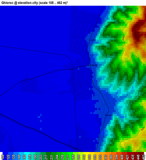
Below is the Elevation map of Ghioroc, which displays elevation range with different colors. Scale of the first map is from 108 to 462 m (354 to 1516 ft) with average elevation of 155.7 meters (=511 ft) [note 1]
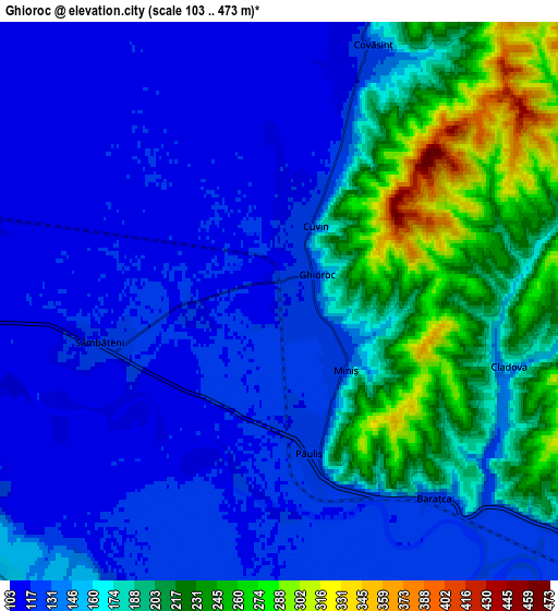
These maps also provides idea of topography and contour of this city, they are displayed at different zoom levels. More info about maps, scale and edge coordinates you can find below images.
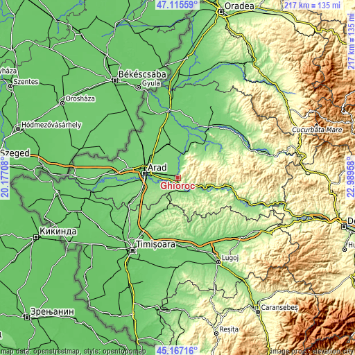
| \ | Map #1 | Map #2 | Topo.Map |
| Scale [m] | 108..462 m | 103..473 m | × |
| Scale [ft] | 354..1516 ft | 338..1552 ft | × |
| Average | 155.7 m = 511 ft | 162.1 m = 532 ft | × |
| Width | 6.77 km = 4.2 mi | 13.54 km = 8.4 mi | 216.6 km = 134.6 mi |
| Height | 6.77 km = 4.2 mi | 13.54 km = 8.4 mi | 216.6 km = 134.6 mi |
| ↑Max Latitude | 46.180436° | 46.210855° | 47.11559° |
| Latitude at center | 46.15° | 46.15° | 46.15° |
| ↓Min Latitude | 46.119547° | 46.089078° | 45.16716° |
| ← Min Longitude | 21.539385° | 21.495439° | 20.17708° |
| Longitude center | 21.58333° | 21.58333° | 21.58333° |
| →Max Longitude | 21.627275° | 21.671221° | 22.98958° |
Nearby cities:
Cities around Ghioroc sort by population:
• Lipova elevation 129 m
10.9 km,  127°
127°
• Zăbrani 157 m
9.6 km,  195°
195°
• Păuliş 118 m
3.7 km,  180°
180°
• Covăsinţ 115 m
5.7 km,  12°
12°
• Radna 126 m
10.1 km, 127°
• Horia 115 m
11.3 km,  305°
305°
• Sâmbăteni 118 m
4.5 km,  257°
257°
• Cuvin 120 m
2.4 km,  19°
19°
• Frumușeni 140 m
10.8 km,  240°
240°
• Chesinț 159 m
11.2 km, 181°
• Mândruloc 115 m
9.1 km,  269°
269°
• Neudorf 127 m
9.4 km,  162°
162°
Multilingual:
 En español:
Ghioroc elevación 120 m.
 En France:
Ghioroc élévation 120 m.


Sources and notes:
- [note 1] Map square and city borders are not equal. Map elevation data is calculated only from area inside that square.
- [src 1] Elevation data from geonames database provided with same terms of usage.
- [src 2] The elevation map of Ghioroc is generated using elevation data from NASA's 3 arcsec (90m) resolution SRTM data.
- [src 3] Base (background) map © OpenStreetMap contributors tiles are generated by Geofabrik and OpenTopoMap.
Copyright & License:
This Ghioroc Elevation Map is licensed under CC BY-SA. You may reuse any part from this page, if you give a proper credit by linking to this URL:
 More info on terms of use page.