Glodeni elevation
Glodeni (Mureş, Comuna Glodeni), Romania elevation is 359 meters and Glodeni elevation in feet is 1178 ft above sea level [src 1]. Glodeni is a seat of a second-order administrative division (feature code) with elevation that is 107 meters (351 ft) bigger than average city elevation in Romania.
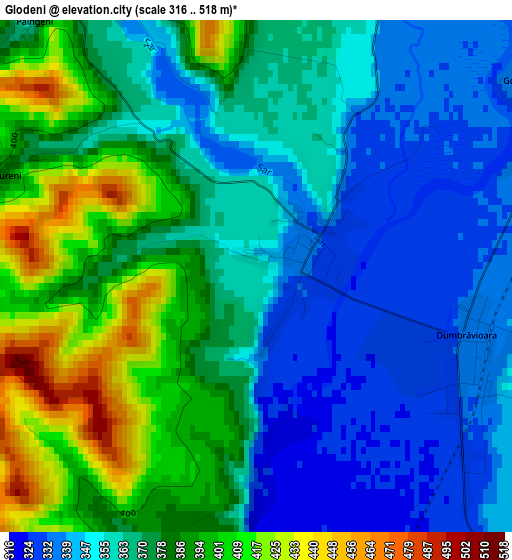
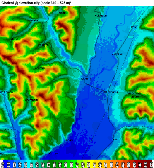
Below is the Elevation map of Glodeni, which displays elevation range with different colors. Scale of the first map is from 316 to 518 m (1037 to 1699 ft) with average elevation of 369.8 meters (=1213 ft) [note 1]
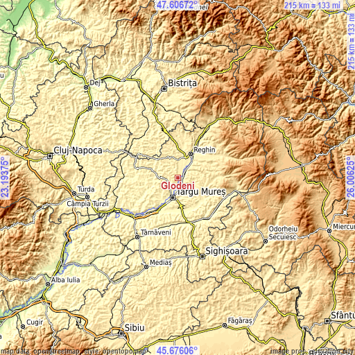
These maps also provides idea of topography and contour of this city, they are displayed at different zoom levels. More info about maps, scale and edge coordinates you can find below images.
| \ | Map #1 | Map #2 | Topo.Map |
| Scale [m] | 316..518 m | 310..523 m | × |
| Scale [ft] | 1037..1699 ft | 1017..1716 ft | × |
| Average | 369.8 m = 1213 ft | 380.5 m = 1248 ft | × |
| Width | 6.71 km = 4.2 mi | 13.42 km = 8.3 mi | 214.7 km = 133.4 mi |
| Height | 6.71 km = 4.2 mi | 13.42 km = 8.3 mi | 214.7 km = 133.4 mi |
| ↑Max Latitude | 46.680158° | 46.710299° | 47.60672° |
| Latitude at center | 46.65° | 46.65° | 46.65° |
| ↓Min Latitude | 46.619825° | 46.589634° | 45.67606° |
| ← Min Longitude | 24.556055° | 24.512109° | 23.19375° |
| Longitude center | 24.6° | 24.6° | 24.6° |
| →Max Longitude | 24.643945° | 24.687891° | 26.00625° |
Nearby cities:
Cities around Glodeni sort by population:
• Târgu-Mureş elevation 319 m
12.4 km,  195°
195°
• Sângeorgiu de Mureş 315 m
8.9 km,  182°
182°
• Sâncraiu de Mureş 308 m
12.3 km,  207°
207°
• Gorneşti 338 m
4.3 km,  56°
56°
• Ernei 333 m
5.9 km,  147°
147°
• Remetea 352 m
10.7 km,  218°
218°
• Livezeni 340 m
11.4 km,  167°
167°
• Petelea 356 m
12 km,  42°
42°
• Voivodeni 339 m
6.1 km,  24°
24°
• Ceuașu de Câmpie 347 m
6.6 km,  253°
253°
• Băla 420 m
10.6 km,  314°
314°
• Sântana de Mureş 311 m
10 km, 202°
Multilingual:
 En español:
Glodeni elevación 359 m.
 En France:
Glodeni élévation 359 m.


Sources and notes:
- [note 1] Map square and city borders are not equal. Map elevation data is calculated only from area inside that square.
- [src 1] Elevation data from geonames database provided with same terms of usage.
- [src 2] The elevation map of Glodeni is generated using elevation data from NASA's 3 arcsec (90m) resolution SRTM data.
- [src 3] Base (background) map © OpenStreetMap contributors tiles are generated by Geofabrik and OpenTopoMap.
Copyright & License:
This Glodeni Elevation Map is licensed under CC BY-SA. You may reuse any part from this page, if you give a proper credit by linking to this URL:
 More info on terms of use page.