Huedin elevation
Huedin (Cluj, Oraş Huedin), Romania elevation is 595 meters and Huedin elevation in feet is 1952 ft above sea level [src 1]. Huedin is a seat of a second-order administrative division (feature code) with elevation that is 343 meters (1125 ft) bigger than average city elevation in Romania.
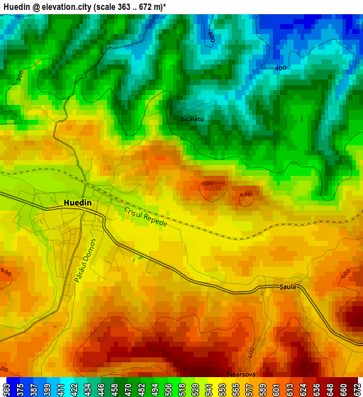
Below is the Elevation map of Huedin, which displays elevation range with different colors. Scale of the first map is from 363 to 672 m (1191 to 2205 ft) with average elevation of 531.1 meters (=1742 ft) [note 1]
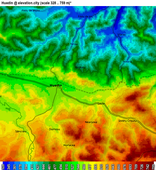
These maps also provides idea of topography and contour of this city, they are displayed at different zoom levels. More info about maps, scale and edge coordinates you can find below images.
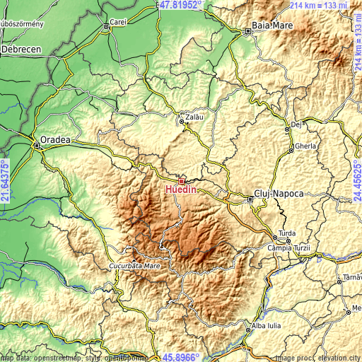
| \ | Map #1 | Map #2 | Topo.Map |
| Scale [m] | 363..672 m | 328..759 m | × |
| Scale [ft] | 1191..2205 ft | 1076..2490 ft | × |
| Average | 531.1 m = 1742 ft | 532.9 m = 1748 ft | × |
| Width | 6.68 km = 4.2 mi | 13.36 km = 8.3 mi | 213.8 km = 132.8 mi |
| Height | 6.68 km = 4.2 mi | 13.36 km = 8.3 mi | 213.8 km = 132.8 mi |
| ↑Max Latitude | 46.896707° | 46.926727° | 47.81952° |
| Latitude at center | 46.86667° | 46.86667° | 46.86667° |
| ↓Min Latitude | 46.836616° | 46.806546° | 45.8966° |
| ← Min Longitude | 23.006055° | 22.962109° | 21.64375° |
| Longitude center | 23.05° | 23.05° | 23.05° |
| →Max Longitude | 23.093945° | 23.137891° | 24.45625° |
Nearby cities:
Cities around Huedin sort by population:
• Almaşu elevation 313 m
10.6 km,  34°
34°
• Călăţele 679 m
11.4 km,  192°
192°
• Cuzăplac 283 m
15.9 km,  45°
45°
• Mărgău 814 m
14.4 km,  206°
206°
• Sâncraiu 573 m
6.3 km,  233°
233°
• Mânăstireni 798 m
11.4 km,  167°
167°
• Izvoru Crişului 626 m
5.3 km,  134°
134°
• Fildu de Jos 400 m
7.5 km,  9°
9°
• Aghireșu 453 m
14.3 km,  87°
87°
• Poieni 479 m
15.7 km,  291°
291°
• Râșca 909 m
14.8 km,  163°
163°
• Săcuieu 620 m
13.2 km,  248°
248°
Multilingual:
 En español:
Huedin elevación 595 m.
 En France:
Huedin élévation 595 m.


Sources and notes:
- [note 1] Map square and city borders are not equal. Map elevation data is calculated only from area inside that square.
- [src 1] Elevation data from geonames database provided with same terms of usage.
- [src 2] The elevation map of Huedin is generated using elevation data from NASA's 3 arcsec (90m) resolution SRTM data.
- [src 3] Base (background) map © OpenStreetMap contributors tiles are generated by Geofabrik and OpenTopoMap.
Copyright & License:
This Huedin Elevation Map is licensed under CC BY-SA. You may reuse any part from this page, if you give a proper credit by linking to this URL:
 More info on terms of use page.