Husnicioara elevation
Husnicioara (Mehedinţi, Comuna Husnicioara), Romania elevation is 283 meters and Husnicioara elevation in feet is 928 ft above sea level [src 1]. Husnicioara is a seat of a second-order administrative division (feature code) with elevation that is 31 meters (102 ft) bigger than average city elevation in Romania.
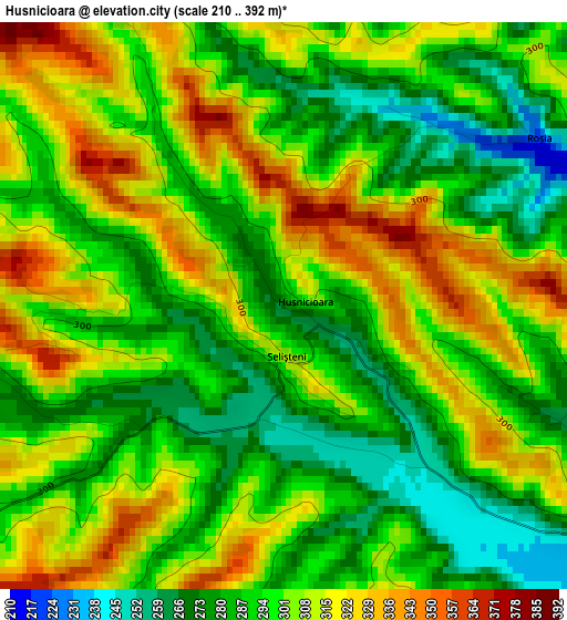
Below is the Elevation map of Husnicioara, which displays elevation range with different colors. Scale of the first map is from 210 to 392 m (689 to 1286 ft) with average elevation of 298.5 meters (=979 ft) [note 1]
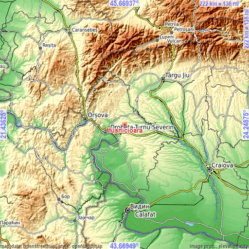
These maps also provides idea of topography and contour of this city, they are displayed at different zoom levels. More info about maps, scale and edge coordinates you can find below images.
| \ | Map #1 | Topo.Map |
| Scale [m] | 210..392 m | × |
| Scale [ft] | 689..1286 ft | × |
| Average | 298.5 m = 979 ft | × |
| Width | 6.95 km = 4.3 mi | 222.4 km = 138.2 mi |
| Height | 6.95 km = 4.3 mi | 222.4 km = 138.2 mi |
| ↑Max Latitude | 44.7093° | 45.66937° |
| Latitude at center | 44.67806° | 44.67806° |
| ↓Min Latitude | 44.646803° | 43.66949° |
| ← Min Longitude | 22.798555° | 21.43625° |
| Longitude center | 22.8425° | 22.8425° |
| →Max Longitude | 22.886445° | 24.24875° |
Nearby cities:
Cities around Husnicioara sort by population:
• Şimian elevation 55 m
12.8 km,  236°
236°
• Cerneți 58 m
11.6 km,  245°
245°
• Izvoru Bârzii 116 m
13.7 km,  283°
283°
• Broşteni 183 m
14.2 km,  49°
49°
• Malovăţ 119 m
9.3 km,  288°
288°
• Floreşti 196 m
12.6 km,  41°
41°
• Căzăneşti 211 m
6.3 km, 37°
• Prunişor 216 m
9.6 km,  142°
142°
• Bistrița 100 m
11.2 km,  202°
202°
• Halânga 84 m
12 km,  271°
271°
• Dudașu 68 m
11.9 km,  256°
256°
• Şişeşti 217 m
11.1 km,  358°
358°
Multilingual:
 En español:
Husnicioara elevación 283 m.
 En France:
Husnicioara élévation 283 m.
 Auf Deutsch:
Husnicioara höhe über dem Meeresspiegel ist 283 m.

Sources and notes:
- [note 1] Map square and city borders are not equal. Map elevation data is calculated only from area inside that square.
- [src 1] Elevation data from geonames database provided with same terms of usage.
- [src 2] The elevation map of Husnicioara is generated using elevation data from NASA's 3 arcsec (90m) resolution SRTM data.
- [src 3] Base (background) map © OpenStreetMap contributors tiles are generated by Geofabrik and OpenTopoMap.
Copyright & License:
This Husnicioara Elevation Map is licensed under CC BY-SA. You may reuse any part from this page, if you give a proper credit by linking to this URL:
 More info on terms of use page.