Ianca elevation
Ianca (Brăila, Oraş Ianca), Romania elevation is 31 meters and Ianca elevation in feet is 102 ft above sea level [src 1]. Ianca is a seat of a second-order administrative division (feature code) with elevation that is 221 meters (725 ft) smaller than average city elevation in Romania.
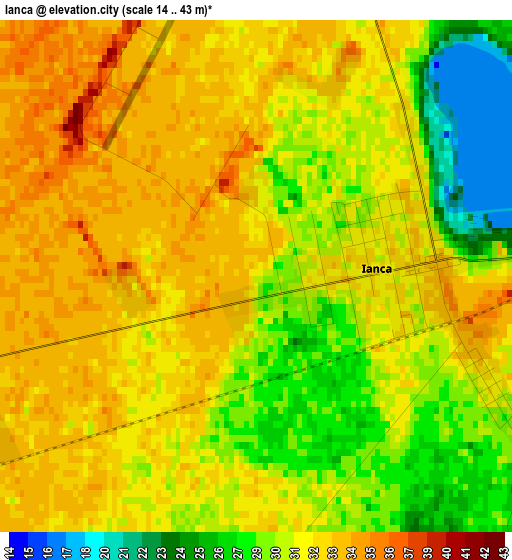
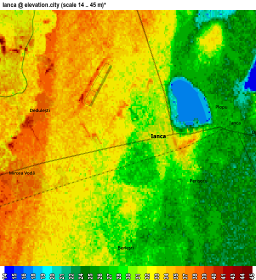
Below is the Elevation map of Ianca, which displays elevation range with different colors. Scale of the first map is from 14 to 43 m (46 to 141 ft) with average elevation of 30.9 meters (=101 ft) [note 1]
These maps also provides idea of topography and contour of this city, they are displayed at different zoom levels. More info about maps, scale and edge coordinates you can find below images.
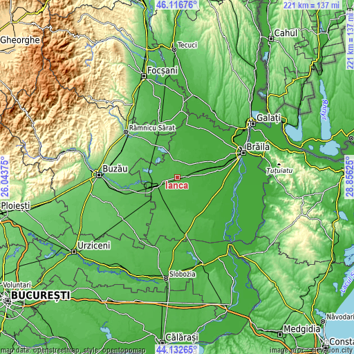
| \ | Map #1 | Map #2 | Topo.Map |
| Scale [m] | 14..43 m | 14..45 m | × |
| Scale [ft] | 46..141 ft | 46..148 ft | × |
| Average | 30.9 m = 101 ft | 30.5 m = 100 ft | × |
| Width | 6.89 km = 4.3 mi | 13.79 km = 8.6 mi | 220.6 km = 137.1 mi |
| Height | 6.89 km = 4.3 mi | 13.79 km = 8.6 mi | 220.6 km = 137.1 mi |
| ↑Max Latitude | 45.164323° | 45.1953° | 46.11676° |
| Latitude at center | 45.13333° | 45.13333° | 45.13333° |
| ↓Min Latitude | 45.10232° | 45.071293° | 44.13265° |
| ← Min Longitude | 27.406055° | 27.362109° | 26.04375° |
| Longitude center | 27.45° | 27.45° | 27.45° |
| →Max Longitude | 27.493945° | 27.537891° | 28.85625° |
Nearby cities:
Cities around Ianca sort by population:
• Şuţeşti elevation 35 m
9.4 km,  351°
351°
• Făurei 42 m
15.4 km,  248°
248°
• Mircea Vodă 37 m
5.5 km, 250°
• Bordei Verde 22 m
10.7 km,  121°
121°
• Movila Miresii 14 m
15 km,  51°
51°
• Vişani 37 m
13.2 km,  278°
278°
• Surdila-Găiseanca 37 m
11.8 km,  231°
231°
• Grădiştea 41 m
15.7 km,  340°
340°
• Plopu 28 m
5.3 km,  71°
71°
• Urleasca 16 m
15.5 km,  88°
88°
• Perișoru 26 m
4.4 km, 121°
• Dedulești 39 m
5 km,  287°
287°
Multilingual:
 En español:
Ianca elevación 31 m.
 En France:
Ianca élévation 31 m.


Sources and notes:
- [note 1] Map square and city borders are not equal. Map elevation data is calculated only from area inside that square.
- [src 1] Elevation data from geonames database provided with same terms of usage.
- [src 2] The elevation map of Ianca is generated using elevation data from NASA's 3 arcsec (90m) resolution SRTM data.
- [src 3] Base (background) map © OpenStreetMap contributors tiles are generated by Geofabrik and OpenTopoMap.
Copyright & License:
This Ianca Elevation Map is licensed under CC BY-SA. You may reuse any part from this page, if you give a proper credit by linking to this URL:
 More info on terms of use page.