Ighiu elevation
Ighiu (Alba, Comuna Ighiu), Romania elevation is 282 meters and Ighiu elevation in feet is 925 ft above sea level [src 1]. Ighiu is a seat of a second-order administrative division (feature code) with elevation that is 30 meters (98 ft) bigger than average city elevation in Romania.
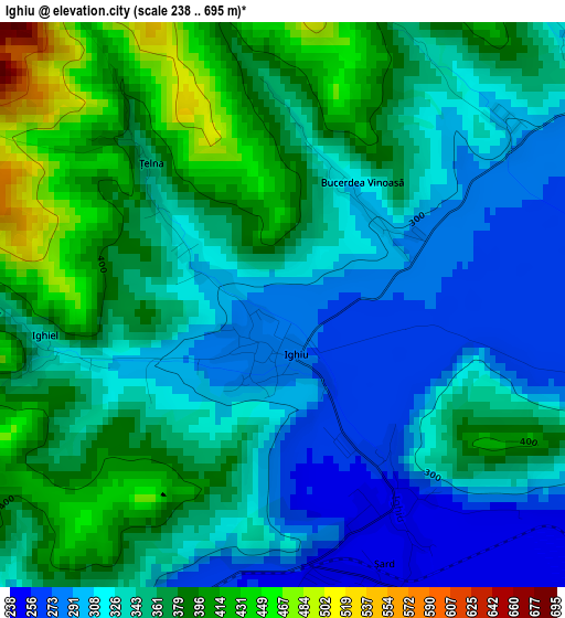
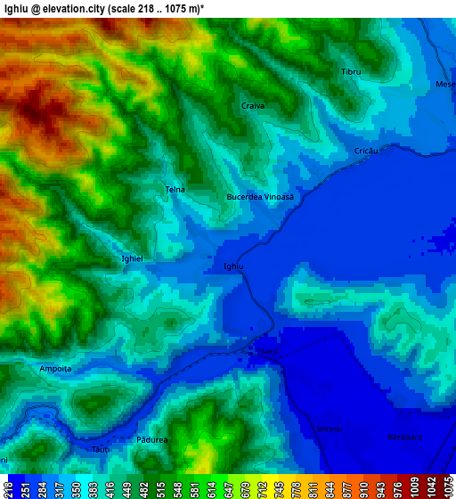
Below is the Elevation map of Ighiu, which displays elevation range with different colors. Scale of the first map is from 238 to 695 m (781 to 2280 ft) with average elevation of 348.6 meters (=1144 ft) [note 1]
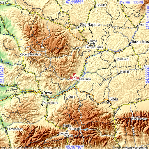
These maps also provides idea of topography and contour of this city, they are displayed at different zoom levels. More info about maps, scale and edge coordinates you can find below images.
| \ | Map #1 | Map #2 | Topo.Map |
| Scale [m] | 238..695 m | 218..1075 m | × |
| Scale [ft] | 781..2280 ft | 715..3527 ft | × |
| Average | 348.6 m = 1144 ft | 434 m = 1424 ft | × |
| Width | 6.77 km = 4.2 mi | 13.54 km = 8.4 mi | 216.6 km = 134.6 mi |
| Height | 6.77 km = 4.2 mi | 13.54 km = 8.4 mi | 216.6 km = 134.6 mi |
| ↑Max Latitude | 46.180436° | 46.210855° | 47.11559° |
| Latitude at center | 46.15° | 46.15° | 46.15° |
| ↓Min Latitude | 46.119547° | 46.089078° | 45.16716° |
| ← Min Longitude | 23.472725° | 23.428779° | 22.11042° |
| Longitude center | 23.51667° | 23.51667° | 23.51667° |
| →Max Longitude | 23.560615° | 23.604561° | 24.92292° |
Nearby cities:
Cities around Ighiu sort by population:
• Alba Iulia elevation 219 m
10.6 km,  150°
150°
• Galda de Jos 266 m
8.5 km,  64°
64°
• Meteş 346 m
9.5 km,  234°
234°
• Stremţ 337 m
11.6 km,  50°
50°
• Sântimbru 222 m
10.4 km,  100°
100°
• Ciugud 219 m
13.5 km, 145°
• Bărăbanț 227 m
7.7 km,  137°
137°
• Cricău 397 m
5.3 km, 46°
• Șard 252 m
2.8 km, 149°
• Micești 244 m
6.2 km, 150°
• Țelna 325 m
1.6 km,  309°
309°
• Ighiel 339 m
2.9 km,  262°
262°
Multilingual:
 En español:
Ighiu elevación 282 m.
 En France:
Ighiu élévation 282 m.


Sources and notes:
- [note 1] Map square and city borders are not equal. Map elevation data is calculated only from area inside that square.
- [src 1] Elevation data from geonames database provided with same terms of usage.
- [src 2] The elevation map of Ighiu is generated using elevation data from NASA's 3 arcsec (90m) resolution SRTM data.
- [src 3] Base (background) map © OpenStreetMap contributors tiles are generated by Geofabrik and OpenTopoMap.
Copyright & License:
This Ighiu Elevation Map is licensed under CC BY-SA. You may reuse any part from this page, if you give a proper credit by linking to this URL:
 More info on terms of use page.