Ileanda elevation
Ileanda (Sălaj, Comuna Ileanda), Romania elevation is 239 meters and Ileanda elevation in feet is 784 ft above sea level [src 1]. Ileanda is a seat of a second-order administrative division (feature code) with elevation that is 13 meters (43 ft) smaller than average city elevation in Romania.
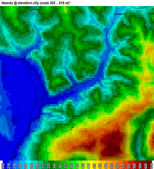
Below is the Elevation map of Ileanda, which displays elevation range with different colors. Scale of the first map is from 202 to 616 m (663 to 2021 ft) with average elevation of 333.2 meters (=1093 ft) [note 1]
These maps also provides idea of topography and contour of this city, they are displayed at different zoom levels. More info about maps, scale and edge coordinates you can find below images.
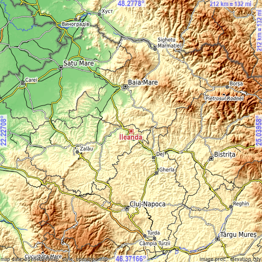
| \ | Map #1 | Topo.Map |
| Scale [m] | 202..616 m | × |
| Scale [ft] | 663..2021 ft | × |
| Average | 333.2 m = 1093 ft | × |
| Width | 6.62 km = 4.1 mi | 211.9 km = 131.7 mi |
| Height | 6.62 km = 4.1 mi | 211.9 km = 131.7 mi |
| ↑Max Latitude | 47.363105° | 48.2778° |
| Latitude at center | 47.33333° | 47.33333° |
| ↓Min Latitude | 47.303538° | 46.37166° |
| ← Min Longitude | 23.589385° | 22.22708° |
| Longitude center | 23.63333° | 23.63333° |
| →Max Longitude | 23.677275° | 25.03958° |
Nearby cities:
Cities around Ileanda sort by population:
• Rus elevation 246 m
6.1 km,  204°
204°
• Valea Chioarului 261 m
15.8 km,  314°
314°
• Letca 235 m
13.8 km,  270°
270°
• Vad 428 m
17.2 km,  149°
149°
• Băbeni 199 m
18 km,  258°
258°
• Vima Mică 459 m
9.7 km,  40°
40°
• Poiana Blenchii 275 m
9.5 km,  112°
112°
• Boiu Mare 419 m
8.3 km,  333°
333°
• Lozna 206 m
12.7 km, 261°
• Șimișna 250 m
11.3 km,  183°
183°
• Gâlgău 222 m
7.7 km,  138°
138°
• Coroieni 394 m
10.7 km,  69°
69°
Multilingual:
 En español:
Ileanda elevación 239 m.
 En France:
Ileanda élévation 239 m.


Sources and notes:
- [note 1] Map square and city borders are not equal. Map elevation data is calculated only from area inside that square.
- [src 1] Elevation data from geonames database provided with same terms of usage.
- [src 2] The elevation map of Ileanda is generated using elevation data from NASA's 3 arcsec (90m) resolution SRTM data.
- [src 3] Base (background) map © OpenStreetMap contributors tiles are generated by Geofabrik and OpenTopoMap.
Copyright & License:
This Ileanda Elevation Map is licensed under CC BY-SA. You may reuse any part from this page, if you give a proper credit by linking to this URL:
 More info on terms of use page.