Ioneşti elevation
Ioneşti (Vâlcea, Comuna Ioneşti), Romania elevation is 176 meters and Ioneşti elevation in feet is 577 ft above sea level [src 1]. Ioneşti is a seat of a second-order administrative division (feature code) with elevation that is 76 meters (249 ft) smaller than average city elevation in Romania.
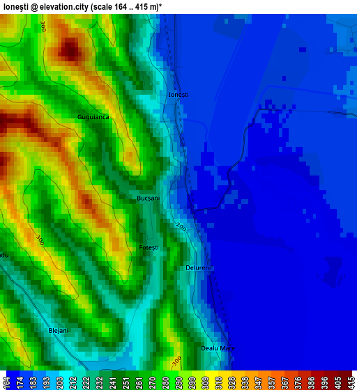
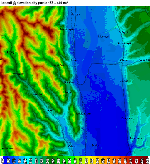
Below is the Elevation map of Ioneşti, which displays elevation range with different colors. Scale of the first map is from 164 to 415 m (538 to 1362 ft) with average elevation of 224 meters (=735 ft) [note 1]
These maps also provides idea of topography and contour of this city, they are displayed at different zoom levels. More info about maps, scale and edge coordinates you can find below images.
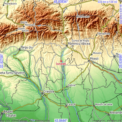
| \ | Map #1 | Map #2 | Topo.Map |
| Scale [m] | 164..415 m | 157..449 m | × |
| Scale [ft] | 538..1362 ft | 515..1473 ft | × |
| Average | 224 m = 735 ft | 246.2 m = 808 ft | × |
| Width | 6.93 km = 4.3 mi | 13.86 km = 8.6 mi | 221.7 km = 137.8 mi |
| Height | 6.93 km = 4.3 mi | 13.86 km = 8.6 mi | 221.7 km = 137.8 mi |
| ↑Max Latitude | 44.881147° | 44.912277° | 45.83834° |
| Latitude at center | 44.85° | 44.85° | 44.85° |
| ↓Min Latitude | 44.818836° | 44.787656° | 43.8444° |
| ← Min Longitude | 24.189385° | 24.145439° | 22.82708° |
| Longitude center | 24.23333° | 24.23333° | 24.23333° |
| →Max Longitude | 24.277275° | 24.321221° | 25.63958° |
Nearby cities:
Cities around Ioneşti sort by population:
• Galicea elevation 253 m
8.4 km,  27°
27°
• Orleşti 220 m
5.7 km,  193°
193°
• Şirineasa 201 m
9.6 km,  344°
344°
• Batârăşti 340 m
7.5 km,  240°
240°
• Drăgoeşti 224 m
6.4 km,  125°
125°
• Valea Mare 190 m
9.8 km,  2°
2°
• Scundu 274 m
3.2 km,  234°
234°
• Amărăşti 216 m
11.4 km,  215°
215°
• Pesceana 319 m
7.5 km,  299°
299°
• Glăvile 340 m
7.5 km, 240°
• Dejești 286 m
9.9 km,  102°
102°
• Olanu 200 m
5.6 km,  70°
70°
Multilingual:
 En español:
Ioneşti elevación 176 m.
 En France:
Ioneşti élévation 176 m.


Sources and notes:
- [note 1] Map square and city borders are not equal. Map elevation data is calculated only from area inside that square.
- [src 1] Elevation data from geonames database provided with same terms of usage.
- [src 2] The elevation map of Ioneşti is generated using elevation data from NASA's 3 arcsec (90m) resolution SRTM data.
- [src 3] Base (background) map © OpenStreetMap contributors tiles are generated by Geofabrik and OpenTopoMap.
Copyright & License:
This Ioneşti Elevation Map is licensed under CC BY-SA. You may reuse any part from this page, if you give a proper credit by linking to this URL:
 More info on terms of use page.