Jegălia elevation
Jegălia (Călăraşi, Comuna Jegălia), Romania elevation is 10 meters and Jegălia elevation in feet is 33 ft above sea level [src 1]. Jegălia is a seat of a second-order administrative division (feature code) with elevation that is 242 meters (794 ft) smaller than average city elevation in Romania.
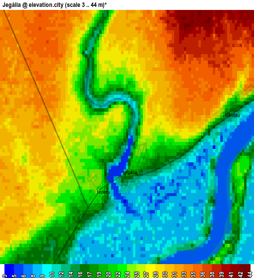
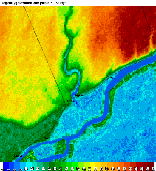
Below is the Elevation map of Jegălia, which displays elevation range with different colors. Scale of the first map is from 3 to 44 m (10 to 144 ft) with average elevation of 23 meters (=75 ft) [note 1]
These maps also provides idea of topography and contour of this city, they are displayed at different zoom levels. More info about maps, scale and edge coordinates you can find below images.
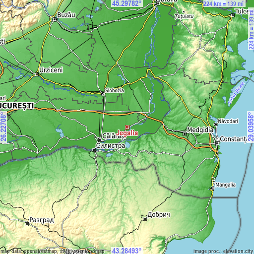
| \ | Map #1 | Map #2 | Topo.Map |
| Scale [m] | 3..44 m | 2..52 m | × |
| Scale [ft] | 10..144 ft | 7..171 ft | × |
| Average | 23 m = 75 ft | 23.9 m = 78 ft | × |
| Width | 6.99 km = 4.3 mi | 13.99 km = 8.7 mi | 223.8 km = 139.1 mi |
| Height | 6.99 km = 4.3 mi | 13.99 km = 8.7 mi | 223.8 km = 139.1 mi |
| ↑Max Latitude | 44.331443° | 44.362869° | 45.29782° |
| Latitude at center | 44.3° | 44.3° | 44.3° |
| ↓Min Latitude | 44.26854° | 44.237064° | 43.28493° |
| ← Min Longitude | 27.589385° | 27.545439° | 26.22708° |
| Longitude center | 27.63333° | 27.63333° | 27.63333° |
| →Max Longitude | 27.677275° | 27.721221° | 29.03958° |
Nearby cities:
Cities around Jegălia sort by population:
• Borcea elevation 29 m
10 km,  68°
68°
• Roseţi 18 m
17.5 km,  237°
237°
• Perişoru 35 m
17.9 km,  338°
338°
• Ștefan cel Mare 37 m
14.1 km,  3°
3°
• Oltina 18 m
15.1 km,  169°
169°
• Unirea 10 m
3.7 km,  180°
180°
• Dichiseni 18 m
10.9 km,  227°
227°
• Gâldău 14 m
3 km,  78°
78°
• Dunăreni 57 m
16.4 km,  130°
130°
• Buliga 17 m
14.2 km,  63°
63°
• Iezeru 22 m
1.7 km,  204°
204°
• Viile 22 m
18.3 km,  147°
147°
Multilingual:
 En español:
Jegălia elevación 10 m.
 En France:
Jegălia élévation 10 m.


Sources and notes:
- [note 1] Map square and city borders are not equal. Map elevation data is calculated only from area inside that square.
- [src 1] Elevation data from geonames database provided with same terms of usage.
- [src 2] The elevation map of Jegălia is generated using elevation data from NASA's 3 arcsec (90m) resolution SRTM data.
- [src 3] Base (background) map © OpenStreetMap contributors tiles are generated by Geofabrik and OpenTopoMap.
Copyright & License:
This Jegălia Elevation Map is licensed under CC BY-SA. You may reuse any part from this page, if you give a proper credit by linking to this URL:
 More info on terms of use page.