Loamneş elevation
Loamneş (Sibiu, Comuna Loamneş), Romania elevation is 425 meters and Loamneş elevation in feet is 1394 ft above sea level [src 1]. Loamneş is a seat of a second-order administrative division (feature code) with elevation that is 173 meters (568 ft) bigger than average city elevation in Romania.
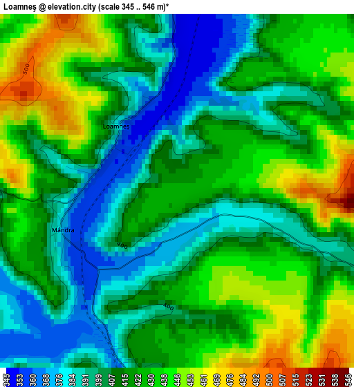
Below is the Elevation map of Loamneş, which displays elevation range with different colors. Scale of the first map is from 345 to 546 m (1132 to 1791 ft) with average elevation of 416 meters (=1365 ft) [note 1]
These maps also provides idea of topography and contour of this city, they are displayed at different zoom levels. More info about maps, scale and edge coordinates you can find below images.
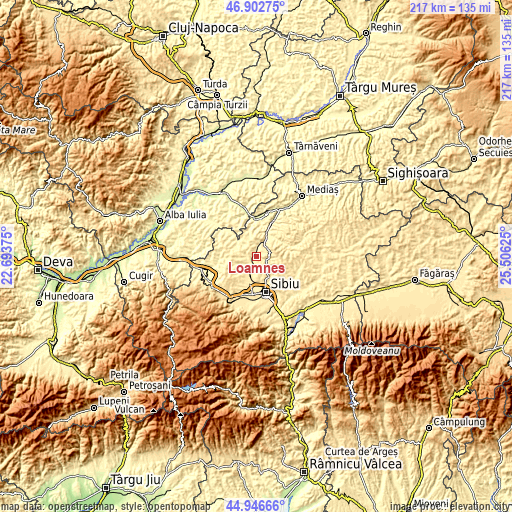
| \ | Map #1 | Topo.Map |
| Scale [m] | 345..546 m | × |
| Scale [ft] | 1132..1791 ft | × |
| Average | 416 m = 1365 ft | × |
| Width | 6.8 km = 4.2 mi | 217.5 km = 135.1 mi |
| Height | 6.8 km = 4.2 mi | 217.5 km = 135.1 mi |
| ↑Max Latitude | 45.963885° | 46.90275° |
| Latitude at center | 45.93333° | 45.93333° |
| ↓Min Latitude | 45.902758° | 44.94666° |
| ← Min Longitude | 24.056055° | 22.69375° |
| Longitude center | 24.1° | 24.1° |
| →Max Longitude | 24.143945° | 25.50625° |
Nearby cities:
Cities around Loamneş sort by population:
• Sibiu elevation 410 m
15.3 km,  165°
165°
• Şeíca Mare 399 m
10 km,  22°
22°
• Ocna Sibiului 435 m
6.8 km,  214°
214°
• Slimnic 489 m
5.5 km,  109°
109°
• Şura Mare 448 m
10.6 km,  150°
150°
• Micăsasa 269 m
16.7 km,  4°
4°
• Şura Mică 418 m
11.4 km,  193°
193°
• Şeica Mică 366 m
13.2 km,  11°
11°
• Agârbiciu 314 m
16.6 km,  25°
25°
• Alămor 420 m
8.2 km,  267°
267°
• Cenade 417 m
14.5 km,  333°
333°
• Ludoş 395 m
15.6 km,  263°
263°
Multilingual:
 En español:
Loamneş elevación 425 m.
 En France:
Loamneş élévation 425 m.


Sources and notes:
- [note 1] Map square and city borders are not equal. Map elevation data is calculated only from area inside that square.
- [src 1] Elevation data from geonames database provided with same terms of usage.
- [src 2] The elevation map of Loamneş is generated using elevation data from NASA's 3 arcsec (90m) resolution SRTM data.
- [src 3] Base (background) map © OpenStreetMap contributors tiles are generated by Geofabrik and OpenTopoMap.
Copyright & License:
This Loamneş Elevation Map is licensed under CC BY-SA. You may reuse any part from this page, if you give a proper credit by linking to this URL:
 More info on terms of use page.