Măgureni elevation
Măgureni (Prahova, Comuna Măgureni), Romania elevation is 364 meters and Măgureni elevation in feet is 1194 ft above sea level [src 1]. Măgureni is a seat of a second-order administrative division (feature code) with elevation that is 112 meters (367 ft) bigger than average city elevation in Romania.
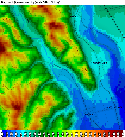
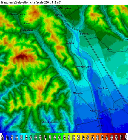
Below is the Elevation map of Măgureni, which displays elevation range with different colors. Scale of the first map is from 310 to 641 m (1017 to 2103 ft) with average elevation of 424.7 meters (=1393 ft) [note 1]
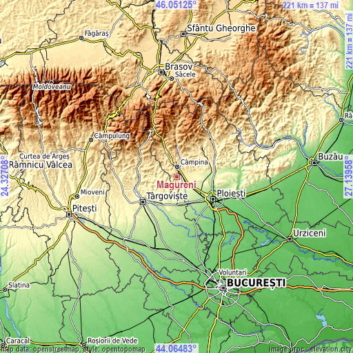
These maps also provides idea of topography and contour of this city, they are displayed at different zoom levels. More info about maps, scale and edge coordinates you can find below images.
| \ | Map #1 | Map #2 | Topo.Map |
| Scale [m] | 310..641 m | 280..719 m | × |
| Scale [ft] | 1017..2103 ft | 919..2359 ft | × |
| Average | 424.7 m = 1393 ft | 417.5 m = 1370 ft | × |
| Width | 6.9 km = 4.3 mi | 13.8 km = 8.6 mi | 220.9 km = 137.3 mi |
| Height | 6.9 km = 4.3 mi | 13.8 km = 8.6 mi | 220.9 km = 137.3 mi |
| ↑Max Latitude | 45.097699° | 45.128712° | 46.05125° |
| Latitude at center | 45.06667° | 45.06667° | 45.06667° |
| ↓Min Latitude | 45.035624° | 45.004561° | 44.06483° |
| ← Min Longitude | 25.689385° | 25.645439° | 24.32708° |
| Longitude center | 25.73333° | 25.73333° | 25.73333° |
| →Max Longitude | 25.777275° | 25.821221° | 27.13958° |
Nearby cities:
Cities around Măgureni sort by population:
• Câmpina elevation 443 m
6.6 km,  1°
1°
• Filipeştii de Pădure 301 m
7.5 km,  169°
169°
• Floreşti 333 m
4.3 km,  115°
115°
• Telega 436 m
8.4 km,  27°
27°
• Băneşti 401 m
4.5 km,  35°
35°
• Urleta 400 m
5.3 km,  64°
64°
• Mislea 358 m
7.9 km, 64°
• Cătina 300 m
7.5 km,  147°
147°
• Tufeni 329 m
8.4 km,  96°
96°
• Drăgăneasa 419 m
5.9 km,  316°
316°
• Lunca Prahovei 332 m
3.7 km,  125°
125°
• Bobolia 369 m
3.1 km,  13°
13°
Multilingual:
 En español:
Măgureni elevación 364 m.
 En France:
Măgureni élévation 364 m.
 Auf Deutsch:
Măgureni höhe über dem Meeresspiegel ist 364 m.

Sources and notes:
- [note 1] Map square and city borders are not equal. Map elevation data is calculated only from area inside that square.
- [src 1] Elevation data from geonames database provided with same terms of usage.
- [src 2] The elevation map of Măgureni is generated using elevation data from NASA's 3 arcsec (90m) resolution SRTM data.
- [src 3] Base (background) map © OpenStreetMap contributors tiles are generated by Geofabrik and OpenTopoMap.
Copyright & License:
This Măgureni Elevation Map is licensed under CC BY-SA. You may reuse any part from this page, if you give a proper credit by linking to this URL:
 More info on terms of use page.