Mărişelu elevation
Mărişelu (Bistriţa-Năsăud, Comuna Mărişelu), Romania elevation is 464 meters and Mărişelu elevation in feet is 1522 ft above sea level [src 1]. Mărişelu is a seat of a second-order administrative division (feature code) with elevation that is 212 meters (696 ft) bigger than average city elevation in Romania.
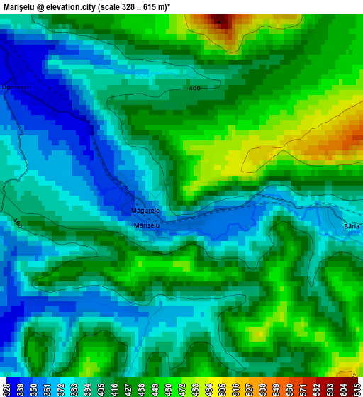
Below is the Elevation map of Mărişelu, which displays elevation range with different colors. Scale of the first map is from 328 to 615 m (1076 to 2018 ft) with average elevation of 412.9 meters (=1355 ft) [note 1]
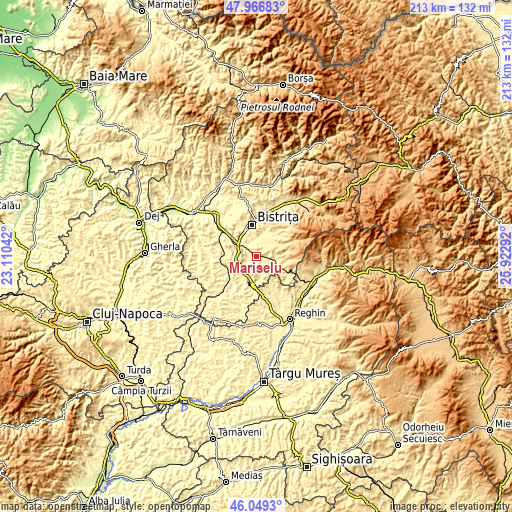
These maps also provides idea of topography and contour of this city, they are displayed at different zoom levels. More info about maps, scale and edge coordinates you can find below images.
| \ | Map #1 | Topo.Map |
| Scale [m] | 328..615 m | × |
| Scale [ft] | 1076..2018 ft | × |
| Average | 412.9 m = 1355 ft | × |
| Width | 6.66 km = 4.1 mi | 213.2 km = 132.5 mi |
| Height | 6.66 km = 4.1 mi | 213.2 km = 132.5 mi |
| ↑Max Latitude | 47.046623° | 47.96683° |
| Latitude at center | 47.01667° | 47.01667° |
| ↓Min Latitude | 46.9867° | 46.0493° |
| ← Min Longitude | 24.472725° | 23.11042° |
| Longitude center | 24.51667° | 24.51667° |
| →Max Longitude | 24.560615° | 25.92292° |
Nearby cities:
Cities around Mărişelu sort by population:
• Teaca elevation 384 m
11.1 km,  180°
180°
• Lechinţa 344 m
12.6 km,  270°
270°
• Şieu-Măgheruş 307 m
12.5 km,  306°
306°
• Şieu 578 m
6.3 km,  90°
90°
• Budacu de Jos 348 m
7.4 km,  0°
0°
• Şieuţ 497 m
10.8 km,  110°
110°
• Galaţii Bistriţei 360 m
9.6 km,  247°
247°
• Budacu de Sus 532 m
11.8 km,  65°
65°
• Viile Tecii 370 m
9.6 km,  195°
195°
• Viișoara 337 m
10.9 km,  332°
332°
• Petriș 409 m
12.5 km,  40°
40°
• Dumitrița 463 m
10.3 km,  53°
53°
Multilingual:
 En español:
Mărişelu elevación 464 m.
 En France:
Mărişelu élévation 464 m.
 Auf Deutsch:
Mărişelu höhe über dem Meeresspiegel ist 464 m.

Sources and notes:
- [note 1] Map square and city borders are not equal. Map elevation data is calculated only from area inside that square.
- [src 1] Elevation data from geonames database provided with same terms of usage.
- [src 2] The elevation map of Mărişelu is generated using elevation data from NASA's 3 arcsec (90m) resolution SRTM data.
- [src 3] Base (background) map © OpenStreetMap contributors tiles are generated by Geofabrik and OpenTopoMap.
Copyright & License:
This Mărişelu Elevation Map is licensed under CC BY-SA. You may reuse any part from this page, if you give a proper credit by linking to this URL:
 More info on terms of use page.