Moțăieni elevation
Moțăieni (Dâmboviţa, Comuna Moţãieni), Romania elevation is 434 meters and Moțăieni elevation in feet is 1424 ft above sea level [src 1]. Moțăieni is a seat of a second-order administrative division (feature code) with elevation that is 182 meters (597 ft) bigger than average city elevation in Romania.
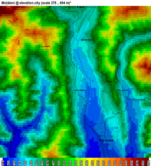
Below is the Elevation map of Moțăieni, which displays elevation range with different colors. Scale of the first map is from 378 to 694 m (1240 to 2277 ft) with average elevation of 478.8 meters (=1571 ft) [note 1]
These maps also provides idea of topography and contour of this city, they are displayed at different zoom levels. More info about maps, scale and edge coordinates you can find below images.
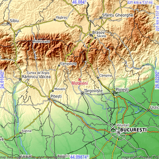
| \ | Map #1 | Topo.Map |
| Scale [m] | 378..694 m | × |
| Scale [ft] | 1240..2277 ft | × |
| Average | 478.8 m = 1571 ft | × |
| Width | 6.9 km = 4.3 mi | 220.7 km = 137.1 mi |
| Height | 6.9 km = 4.3 mi | 220.7 km = 137.1 mi |
| ↑Max Latitude | 45.131011° | 46.084° |
| Latitude at center | 45.1° | 45.1° |
| ↓Min Latitude | 45.068972° | 44.09874° |
| ← Min Longitude | 25.372725° | 24.01042° |
| Longitude center | 25.41667° | 25.41667° |
| →Max Longitude | 25.460615° | 26.82292° |
Nearby cities:
Cities around Moțăieni sort by population:
• Pucioasa elevation 407 m
2.7 km,  153°
153°
• Brăneşti 360 m
7.4 km,  180°
180°
• Fieni 486 m
3.7 km,  0°
0°
• Buciumeni 475 m
6.1 km,  25°
25°
• Vulcana Băi 388 m
3.5 km,  230°
230°
• Vârfuri 512 m
7.8 km,  90°
90°
• Dealu Mare 508 m
7.2 km,  20°
20°
• Vulcana de Sus 432 m
4.6 km,  271°
271°
• Gura Vulcanei 354 m
8.6 km,  190°
190°
• Râu Alb de Jos 492 m
6.8 km,  306°
306°
• Glodeni 412 m
5 km,  144°
144°
• Bădeni 503 m
6 km,  349°
349°
Multilingual:
 En español:
Moțăieni elevación 434 m.
 En France:
Moțăieni élévation 434 m.
 Auf Deutsch:
Moțăieni höhe über dem Meeresspiegel ist 434 m.

Sources and notes:
- [note 1] Map square and city borders are not equal. Map elevation data is calculated only from area inside that square.
- [src 1] Elevation data from geonames database provided with same terms of usage.
- [src 2] The elevation map of Moțăieni is generated using elevation data from NASA's 3 arcsec (90m) resolution SRTM data.
- [src 3] Base (background) map © OpenStreetMap contributors tiles are generated by Geofabrik and OpenTopoMap.
Copyright & License:
This Moțăieni Elevation Map is licensed under CC BY-SA. You may reuse any part from this page, if you give a proper credit by linking to this URL:
 More info on terms of use page.