Orăştioara de Sus elevation
Orăştioara de Sus (Hunedoara, Comuna Orăştioara de Sus), Romania elevation is 346 meters and Orăştioara de Sus elevation in feet is 1135 ft above sea level [src 1]. Orăştioara de Sus is a seat of a second-order administrative division (feature code) with elevation that is 94 meters (308 ft) bigger than average city elevation in Romania.
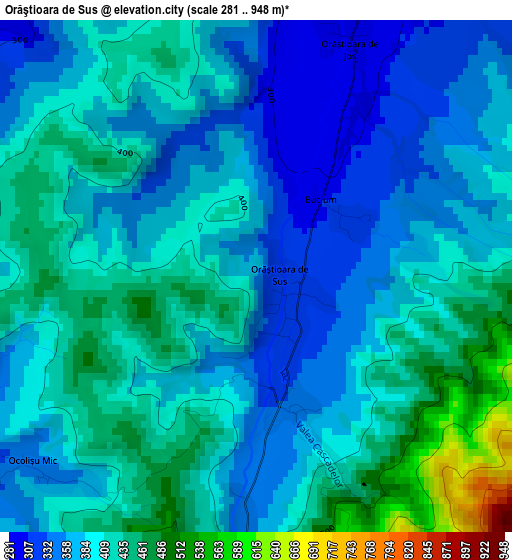
Below is the Elevation map of Orăştioara de Sus, which displays elevation range with different colors. Scale of the first map is from 281 to 948 m (922 to 3110 ft) with average elevation of 395.6 meters (=1298 ft) [note 1]
These maps also provides idea of topography and contour of this city, they are displayed at different zoom levels. More info about maps, scale and edge coordinates you can find below images.
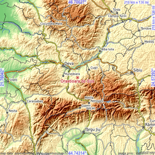
| \ | Map #1 | Topo.Map |
| Scale [m] | 281..948 m | × |
| Scale [ft] | 922..3110 ft | × |
| Average | 395.6 m = 1298 ft | × |
| Width | 6.82 km = 4.2 mi | 218.3 km = 135.6 mi |
| Height | 6.82 km = 4.2 mi | 218.3 km = 135.6 mi |
| ↑Max Latitude | 45.763995° | 46.70627° |
| Latitude at center | 45.73333° | 45.73333° |
| ↓Min Latitude | 45.702648° | 44.74314° |
| ← Min Longitude | 23.122725° | 21.76042° |
| Longitude center | 23.16667° | 23.16667° |
| →Max Longitude | 23.210615° | 24.57292° |
Nearby cities:
Cities around Orăştioara de Sus sort by population:
• Orăştie elevation 224 m
11.4 km,  13°
13°
• Călan 245 m
14.2 km,  270°
270°
• Beriu 260 m
5.7 km, 13°
• Romos 283 m
14.3 km,  39°
39°
• Boşorod 310 m
8.5 km,  229°
229°
• Rapoltu Mare 217 m
16.7 km,  332°
332°
• Turdaş 195 m
13.5 km,  343°
343°
• Băcia 206 m
13.8 km,  302°
302°
• Căstău 245 m
9.7 km,  21°
21°
• Pricaz 207 m
14 km,  1°
1°
• Mărtineşti 222 m
9.6 km, 344°
• Bretea Română 262 m
14.1 km,  235°
235°
Multilingual:
 En español:
Orăştioara de Sus elevación 346 m.
 En France:
Orăştioara de Sus élévation 346 m.
 Auf Deutsch:
Orăştioara de Sus höhe über dem Meeresspiegel ist 346 m.

Sources and notes:
- [note 1] Map square and city borders are not equal. Map elevation data is calculated only from area inside that square.
- [src 1] Elevation data from geonames database provided with same terms of usage.
- [src 2] The elevation map of Orăştioara de Sus is generated using elevation data from NASA's 3 arcsec (90m) resolution SRTM data.
- [src 3] Base (background) map © OpenStreetMap contributors tiles are generated by Geofabrik and OpenTopoMap.
Copyright & License:
This Orăştioara de Sus Elevation Map is licensed under CC BY-SA. You may reuse any part from this page, if you give a proper credit by linking to this URL:
 More info on terms of use page.