Otopeni elevation
Otopeni (Ilfov, Oraş Otopeni), Romania elevation is 94 meters and Otopeni elevation in feet is 308 ft above sea level [src 1]. Otopeni is a seat of a second-order administrative division (feature code) with elevation that is 158 meters (518 ft) smaller than average city elevation in Romania.
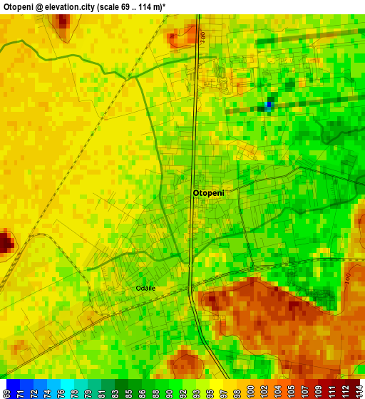
Below is the Elevation map of Otopeni, which displays elevation range with different colors. Scale of the first map is from 69 to 114 m (226 to 374 ft) with average elevation of 95 meters (=312 ft) [note 1]
These maps also provides idea of topography and contour of this city, they are displayed at different zoom levels. More info about maps, scale and edge coordinates you can find below images.
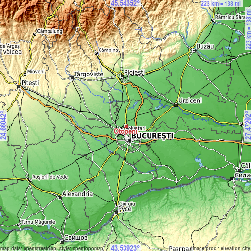
| \ | Map #1 | Map #2 | Topo.Map |
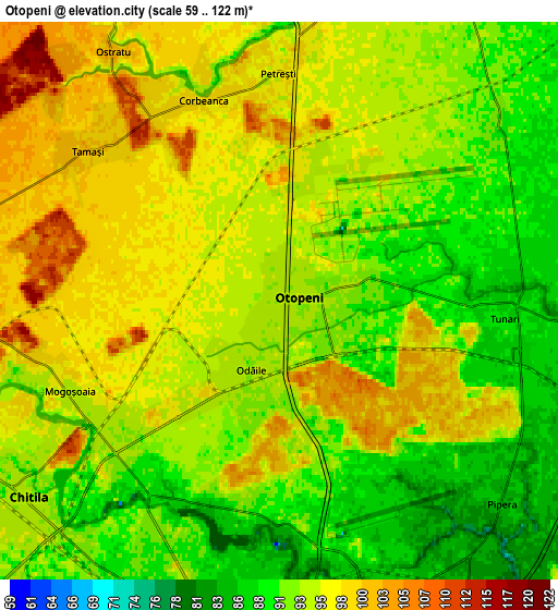
| Scale [m] | 69..114 m | 59..122 m | × |
| Scale [ft] | 226..374 ft | 194..400 ft | × |
| Average | 95 m = 312 ft | 94 m = 308 ft | × |
| Width | 6.96 km = 4.3 mi | 13.93 km = 8.7 mi | 222.9 km = 138.5 mi |
| Height | 6.96 km = 4.3 mi | 13.93 km = 8.7 mi | 222.8 km = 138.4 mi |
| ↑Max Latitude | 44.581309° | 44.612601° | 45.54352° |
| Latitude at center | 44.55° | 44.55° | 44.55° |
| ↓Min Latitude | 44.518674° | 44.487332° | 43.53923° |
| ← Min Longitude | 26.022725° | 25.978779° | 24.66042° |
| Longitude center | 26.06667° | 26.06667° | 26.06667° |
| →Max Longitude | 26.110615° | 26.154561° | 27.47292° |
Nearby cities:
Cities around Otopeni sort by population:
• Sector 1 elevation 86 m
6.6 km,  192°
192°
• Voluntari 82 m
10.8 km,  128°
128°
• Buftea 107 m
9.4 km,  277°
277°
• Chitila 93 m
8.2 km,  235°
235°
• Baloteşti 94 m
8.4 km,  28°
28°
• Mogoşoaia 95 m
5.8 km,  246°
246°
• Ştefăneştii de Jos 84 m
10.7 km,  99°
99°
• Tunari 85 m
6.6 km,  90°
90°
• Corbeanca 97 m
5.7 km,  346°
346°
• Buciumeni 100 m
8.1 km,  269°
269°
• Dârza 109 m
10.9 km,  301°
301°
• Tamași 100 m
6.1 km,  309°
309°
Multilingual:
 En español:
Otopeni elevación 94 m.
 En France:
Otopeni élévation 94 m.


Sources and notes:
- [note 1] Map square and city borders are not equal. Map elevation data is calculated only from area inside that square.
- [src 1] Elevation data from geonames database provided with same terms of usage.
- [src 2] The elevation map of Otopeni is generated using elevation data from NASA's 3 arcsec (90m) resolution SRTM data.
- [src 3] Base (background) map © OpenStreetMap contributors tiles are generated by Geofabrik and OpenTopoMap.
Copyright & License:
This Otopeni Elevation Map is licensed under CC BY-SA. You may reuse any part from this page, if you give a proper credit by linking to this URL:
 More info on terms of use page.