Padina elevation
Padina (Buzău, Comuna Padina), Romania elevation is 56 meters and Padina elevation in feet is 184 ft above sea level [src 1]. Padina is a seat of a second-order administrative division (feature code) with elevation that is 196 meters (643 ft) smaller than average city elevation in Romania.
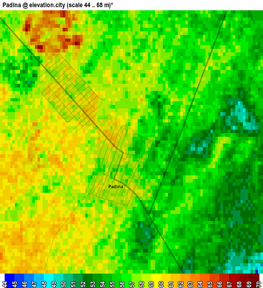
Below is the Elevation map of Padina, which displays elevation range with different colors. Scale of the first map is from 44 to 68 m (144 to 223 ft) with average elevation of 56.5 meters (=185 ft) [note 1]
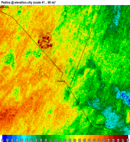
These maps also provides idea of topography and contour of this city, they are displayed at different zoom levels. More info about maps, scale and edge coordinates you can find below images.
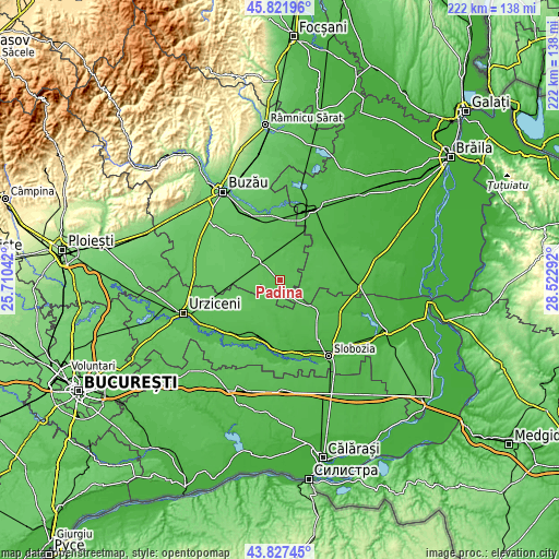
| \ | Map #1 | Map #2 | Topo.Map |
| Scale [m] | 44..68 m | 41..68 m | × |
| Scale [ft] | 144..223 ft | 135..223 ft | × |
| Average | 56.5 m = 185 ft | 55.7 m = 183 ft | × |
| Width | 6.93 km = 4.3 mi | 13.86 km = 8.6 mi | 221.8 km = 137.8 mi |
| Height | 6.93 km = 4.3 mi | 13.86 km = 8.6 mi | 221.8 km = 137.8 mi |
| ↑Max Latitude | 44.864486° | 44.895625° | 45.82196° |
| Latitude at center | 44.83333° | 44.83333° | 44.83333° |
| ↓Min Latitude | 44.802157° | 44.770968° | 43.82745° |
| ← Min Longitude | 27.072725° | 27.028779° | 25.71042° |
| Longitude center | 27.11667° | 27.11667° | 27.11667° |
| →Max Longitude | 27.160615° | 27.204561° | 28.52292° |
Nearby cities:
Cities around Padina sort by population:
• Pogoanele elevation 62 m
13.1 km,  315°
315°
• Ruşeţu 47 m
15.2 km,  31°
31°
• Cocora 49 m
12.3 km,  205°
205°
• Reviga 48 m
13 km,  185°
185°
• Ciocile 50 m
9.4 km,  101°
101°
• Miloşeşti 48 m
14.4 km,  140°
140°
• Luciu 57 m
15.1 km,  349°
349°
• Scutelnici 71 m
15.9 km,  276°
276°
• Căldărăști 62 m
9.4 km, 315°
• Largu 48 m
15.1 km,  10°
10°
• Colelia 57 m
11.8 km,  227°
227°
• Rovine 46 m
15.4 km, 186°
Multilingual:
 En español:
Padina elevación 56 m.
 En France:
Padina élévation 56 m.


Sources and notes:
- [note 1] Map square and city borders are not equal. Map elevation data is calculated only from area inside that square.
- [src 1] Elevation data from geonames database provided with same terms of usage.
- [src 2] The elevation map of Padina is generated using elevation data from NASA's 3 arcsec (90m) resolution SRTM data.
- [src 3] Base (background) map © OpenStreetMap contributors tiles are generated by Geofabrik and OpenTopoMap.
Copyright & License:
This Padina Elevation Map is licensed under CC BY-SA. You may reuse any part from this page, if you give a proper credit by linking to this URL:
 More info on terms of use page.